Hanover geodata
Hanover (Ontario) is a populated place; located in Canada in America/Toronto (GMT-4) time zone. With population of 7,255 people, there are 394 cities with bigger population in this country. Compared to other cities in Canada, 90.7% of cities are located further ↑North; 59.2% of cities are located further →East and 67.8% of cities have lower elevation than Hanover. Note1


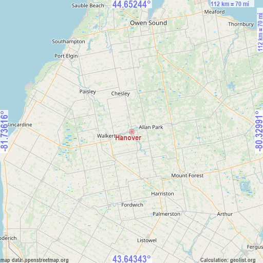
Hanover GPS coordinates[2]
44° 9' 0.324" North, 81° 1' 58.908" West
| Map corner | latitude | longitude |
|---|---|---|
| Upper-left | 44.65244°, | -81.73616° |
| Center: | 44.15009°, | -81.03303° |
| Lower-right: | 43.64343°, | -80.32991° |
| Map W x H: | 112.2×112.2 km | = 69.7×69.7mi |
| max Lat: | 73.03752° ⇑90.7% North |
| Hanover: | 44.15009° |
| min Lat: | ⇓9.3% South 42.05009° |
| min Long | Hanover | max Long |
| -139.43328° | -81.03303° | -52.70931° |
| W 40.8%⇐ | ⇒59.2% E |
Elevation
Elevation of Hanover is 277 m = 909 ft, and this is 22.6 m = 74 ft above average elevation for this country.
| Max E: |
1518 m = 4980 ft | 32.2% |
| Hanover | 277 m 909 ft | |
| Avg. | 254.4 m = 835 ft | |
Min E: |
-2 m = -7 ft | 67.8% |
See also: Canada elevation on elevation.city.
Geographical zone
Hanover is located in North temperate zone (between Tropic of Cancer and the Arctic Circle). Distance of this Northern Tropic circle is 2303.1 km =1431.1 mi to South.| Distance of | km | miles | from Hanover |
|---|---|---|---|
| North Pole | 5098 | 3167.7 | to North |
| Arctic Circle | 2492.1 | 1548.5 | to North |
| Tropic Cancer | 2303.1 | 1431.1 | to South |
| Equator | 4909 | 3050.3 | to South |


Nearby cities:
15 places around Hanover: (largest is in red/bold)
• Brussels
49.5 km =30.8 mi,  200°
200°
• Harriston
30.3 km =18.8 mi,  156°
156°
• Huron East
63 km =39.1 mi, 199°
• Kincardine
48 km =29.8 mi,  274°
274°
• Linwood
67.8 km =42.1 mi, 158°
• Listowel
46.8 km =29.1 mi,  171°
171°
• Markdale
35.7 km =22.2 mi,  58°
58°
• Meaford
60.9 km =37.8 mi,  33°
33°
• Mildmay
13 km =8.1 mi,  210°
210°
• Neustadt
7.9 km =4.9 mi, 160°
• North Perth
47.5 km =29.5 mi, 173°
• Owen Sound
46.9 km =29.1 mi,  8°
8°
• Paisley
25.8 km =16 mi,  312°
312°
• Shelburne
66.6 km =41.4 mi,  96°
96°
• Wingham
36.7 km =22.8 mi,  217°
217°
Sources, notices
• [Note1] Compared only with cities in Canada existing in our database
• [Src1] Map data: © OpenStreetMap contributors (CC-BY-SA)
• [Src2] Other city data from geonames.org with taken over terms of usage.
• [Src3] Geographical zone / Annual Mean Temperature by Robert A. Rohde @ Wikipedia
