Brussels geodata
Brussels (Ontario) is a populated place; located in Canada in America/Toronto (GMT-4) time zone. With population of 1,158 people, there are 970 cities with bigger population in this country. Compared to other cities in Canada, 93.6% of cities are located further ↑North; 60% of cities are located further →East and 73.9% of cities have lower elevation than Brussels. Note1


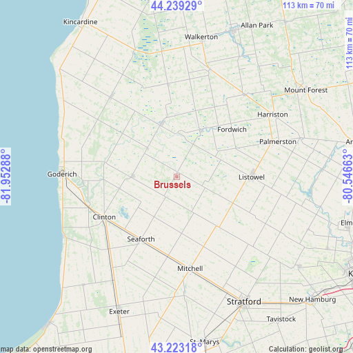
Brussels GPS coordinates[2]
43° 44' 0.204" North, 81° 14' 59.1" West
| Map corner | latitude | longitude |
|---|---|---|
| Upper-left | 44.23929°, | -81.95288° |
| Center: | 43.73339°, | -81.24975° |
| Lower-right: | 43.22318°, | -80.54663° |
| Map W x H: | 113×113 km | = 70.2×70.2mi |
| max Lat: | 73.03752° ⇑93.6% North |
| Brussels: | 43.73339° |
| min Lat: | ⇓6.4% South 42.05009° |
| min Long | Brussels | max Long |
| -139.43328° | -81.24975° | -52.70931° |
| W 40%⇐ | ⇒60% E |
Elevation
Elevation of Brussels is 348 m = 1142 ft, and this is 93.6 m = 307 ft above average elevation for this country.
| Max E: |
1518 m = 4980 ft | 26.1% |
| Brussels | 348 m 1142 ft | |
| Avg. | 254.4 m = 835 ft | |
Min E: |
-2 m = -7 ft | 73.9% |
See also: Canada elevation on elevation.city.
Geographical zone
Brussels is located in North temperate zone (between Tropic of Cancer and the Arctic Circle). Distance of this Northern Tropic circle is 2256.8 km =1402.3 mi to South.| Distance of | km | miles | from Brussels |
|---|---|---|---|
| North Pole | 5144.4 | 3196.6 | to North |
| Arctic Circle | 2538.5 | 1577.4 | to North |
| Tropic Cancer | 2256.8 | 1402.3 | to South |
| Equator | 4862.7 | 3021.5 | to South |


Nearby cities:
15 places around Brussels: (largest is in red/bold)
• Bluewater
40.9 km =25.4 mi,  223°
223°
• Goderich
37.3 km =23.2 mi,  271°
271°
• Hanover
49.5 km =30.8 mi,  20°
20°
• Harriston
34.8 km =21.6 mi,  57°
57°
• Huron East
13.6 km =8.5 mi,  197°
197°
• Linwood
45.2 km =28.1 mi,  111°
111°
• Listowel
24.1 km =15 mi,  89°
89°
• Mildmay
36.8 km =22.9 mi, 16°
• Neustadt
43.8 km =27.2 mi,  27°
27°
• North Perth
22.7 km =14.1 mi, 92°
• Seaforth
23.7 km =14.7 mi,  210°
210°
• South Huron
51.1 km =31.8 mi, 204°
• Stratford
47.4 km =29.5 mi,  149°
149°
• Wellesley
48.5 km =30.1 mi,  125°
125°
• Wingham
17.9 km =11.1 mi,  343°
343°
Sources, notices
• [Note1] Compared only with cities in Canada existing in our database
• [Src1] Map data: © OpenStreetMap contributors (CC-BY-SA)
• [Src2] Other city data from geonames.org with taken over terms of usage.
• [Src3] Geographical zone / Annual Mean Temperature by Robert A. Rohde @ Wikipedia
