Neustadt geodata
Neustadt (Ontario) is a populated place; located in Canada in America/Toronto (GMT-4) time zone. With population of 517 people, there are 1173 cities with bigger population in this country. Compared to other cities in Canada, 91.1% of cities are located further ↑North; 59% of cities are located further →East and 68.9% of cities have lower elevation than Neustadt. Note1


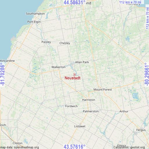
Neustadt GPS coordinates[2]
44° 5' 0.204" North, 80° 59' 59.028" West
| Map corner | latitude | longitude |
|---|---|---|
| Upper-left | 44.58631°, | -81.70286° |
| Center: | 44.08339°, | -80.99973° |
| Lower-right: | 43.57616°, | -80.29661° |
| Map W x H: | 112.3×112.3 km | = 69.8×69.8mi |
| max Lat: | 73.03752° ⇑91.1% North |
| Neustadt: | 44.08339° |
| min Lat: | ⇓8.9% South 42.05009° |
| min Long | Neustadt | max Long |
| -139.43328° | -80.99973° | -52.70931° |
| W 41%⇐ | ⇒59% E |
Elevation
Elevation of Neustadt is 290 m = 951 ft, and this is 35.6 m = 117 ft above average elevation for this country.
| Max E: |
1518 m = 4980 ft | 31.1% |
| Neustadt | 290 m 951 ft | |
| Avg. | 254.4 m = 835 ft | |
Min E: |
-2 m = -7 ft | 68.9% |
See also: Canada elevation on elevation.city.
Geographical zone
Neustadt is located in North temperate zone (between Tropic of Cancer and the Arctic Circle). Distance of this Northern Tropic circle is 2295.7 km =1426.5 mi to South.| Distance of | km | miles | from Neustadt |
|---|---|---|---|
| North Pole | 5105.4 | 3172.3 | to North |
| Arctic Circle | 2499.6 | 1553.2 | to North |
| Tropic Cancer | 2295.7 | 1426.5 | to South |
| Equator | 4901.6 | 3045.7 | to South |


Nearby cities:
15 places around Neustadt: (largest is in red/bold)
• Brussels
43.8 km =27.2 mi,  207°
207°
• Hanover
7.9 km =4.9 mi,  340°
340°
• Harriston
22.4 km =13.9 mi,  155°
155°
• Huron East
57.2 km =35.5 mi,  204°
204°
• Kincardine
51.8 km =32.2 mi,  282°
282°
• Linwood
59.9 km =37.2 mi, 158°
• Listowel
39.1 km =24.3 mi,  174°
174°
• Markdale
38.1 km =23.7 mi,  47°
47°
• Meaford
65.9 km =40.9 mi,  27°
27°
• Mildmay
10 km =6.2 mi,  248°
248°
• North Perth
39.9 km =24.8 mi,  176°
176°
• Owen Sound
54 km =33.6 mi,  4°
4°
• Paisley
33 km =20.5 mi,  318°
318°
• Shelburne
63.6 km =39.5 mi,  90°
90°
• Wingham
33.1 km =20.6 mi,  228°
228°
Sources, notices
• [Note1] Compared only with cities in Canada existing in our database
• [Src1] Map data: © OpenStreetMap contributors (CC-BY-SA)
• [Src2] Other city data from geonames.org with taken over terms of usage.
• [Src3] Geographical zone / Annual Mean Temperature by Robert A. Rohde @ Wikipedia
