Paisley geodata
Paisley (Ontario) is a populated place; located in Canada in America/Toronto (GMT-4) time zone. With population of 1,045 people, there are 1026 cities with bigger population in this country. Compared to other cities in Canada, 88.7% of cities are located further ↑North; 60.1% of cities are located further →East and 57.1% of cities have lower elevation than Paisley. Note1


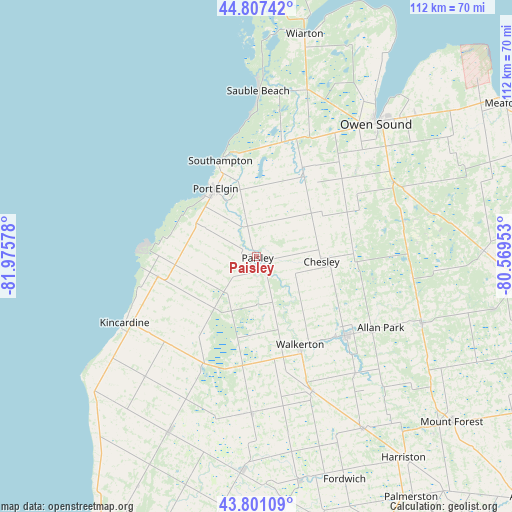
Paisley GPS coordinates[2]
44° 18' 23.076" North, 81° 16' 21.54" West
| Map corner | latitude | longitude |
|---|---|---|
| Upper-left | 44.80742°, | -81.97578° |
| Center: | 44.30641°, | -81.27265° |
| Lower-right: | 43.80109°, | -80.56953° |
| Map W x H: | 111.9×111.9 km | = 69.5×69.5mi |
| max Lat: | 73.03752° ⇑88.7% North |
| Paisley: | 44.30641° |
| min Lat: | ⇓11.3% South 42.05009° |
| min Long | Paisley | max Long |
| -139.43328° | -81.27265° | -52.70931° |
| W 39.9%⇐ | ⇒60.1% E |
Elevation
Elevation of Paisley is 214 m = 702 ft, and this is 40.4 m = 133 ft below average elevation for this country.
| Max E: |
1518 m = 4980 ft | 42.9% |
| Avg. | 254.4 m = 835 ft | |
| Paisley | 214 m = 702 ft | |
Min E: |
-2 m = -7 ft | 57.1% |
See also: Canada elevation on elevation.city.
Geographical zone
Paisley is located in North temperate zone (between Tropic of Cancer and the Arctic Circle). Distance of this Northern Tropic circle is 2320.5 km =1441.9 mi to South.| Distance of | km | miles | from Paisley |
|---|---|---|---|
| North Pole | 5080.7 | 3157 | to North |
| Arctic Circle | 2474.8 | 1537.8 | to North |
| Tropic Cancer | 2320.5 | 1441.9 | to South |
| Equator | 4926.4 | 3061.1 | to South |


Nearby cities:
15 places around Paisley: (largest is in red/bold)
• Brussels
63.7 km =39.6 mi,  178°
178°
• Goderich
72 km =44.7 mi,  209°
209°
• Hanover
25.8 km =16 mi,  132°
132°
• Harriston
54.9 km =34.1 mi,  145°
145°
• Huron East
76.7 km =47.7 mi, 181°
• Kincardine
31.8 km =19.8 mi,  244°
244°
• Listowel
68.7 km =42.7 mi,  157°
157°
• Markdale
49.6 km =30.8 mi,  88°
88°
• Meaford
62.3 km =38.7 mi,  57°
57°
• Mildmay
31.1 km =19.3 mi, 156°
• Neustadt
33 km =20.5 mi,  138°
138°
• North Perth
69.1 km =42.9 mi, 159°
• Owen Sound
39 km =24.2 mi,  42°
42°
• Seaforth
84.7 km =52.6 mi,  186°
186°
• Wingham
46.6 km =29 mi, 183°
Sources, notices
• [Note1] Compared only with cities in Canada existing in our database
• [Src1] Map data: © OpenStreetMap contributors (CC-BY-SA)
• [Src2] Other city data from geonames.org with taken over terms of usage.
• [Src3] Geographical zone / Annual Mean Temperature by Robert A. Rohde @ Wikipedia
