Prince Albert geodata
Prince Albert (Saskatchewan) is a populated place; located in Canada in America/Regina (GMT-6) time zone. With population of 35,102 people, there are 128 cities with bigger population in this country. Compared to other cities in Canada, 89.6% of cities are located further ↓South; 72.6% of cities are located further →East and 79.5% of cities have lower elevation than Prince Albert. Note1


Prince Albert GPS coordinates[2]
53° 12' 0.288" North, 105° 46' 3.792" West
| Map corner | latitude | longitude |
|---|---|---|
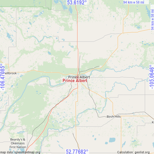
| Upper-left | 53.6192°, | -106.47085° |
| Center: | 53.20008°, | -105.76772° |
| Lower-right: | 52.77682°, | -105.0646° |
| Map W x H: | 93.7×93.7 km | = 58.2×58.2mi |
| max Lat: | 73.03752° ⇑10.4% North |
| Prince Albert: | 53.20008° |
| min Lat: | ⇓89.6% South 42.05009° |
| min Long | Prince Albert | max Long |
| -139.43328° | -105.76772° | -52.70931° |
| W 27.4%⇐ | ⇒72.6% E |
Elevation
Elevation of Prince Albert is 431 m = 1414 ft, and this is 176.6 m = 579 ft above average elevation for this country.
| Max E: |
1518 m = 4980 ft | 20.5% |
| Prince Albert | 431 m 1414 ft | |
| Avg. | 254.4 m = 835 ft | |
Min E: |
-2 m = -7 ft | 79.5% |
See also: Canada elevation on elevation.city.
Geographical zone
Prince Albert is located in North temperate zone (between Tropic of Cancer and the Arctic Circle). Distance of this North polar circle is 1485.9 km =923.3 mi to North.| Distance of | km | miles | from Prince Albert |
|---|---|---|---|
| North Pole | 4091.8 | 2542.5 | to North |
| Arctic Circle | 1485.9 | 923.3 | to North |
| Tropic Cancer | 3309.4 | 2056.4 | to South |
| Equator | 5915.3 | 3675.6 | to South |


Nearby cities:
15 places around Prince Albert: (largest is in red/bold)
• Carrot River
145.6 km =90.5 mi,  86°
86°
• Dalmeny
117.5 km =73 mi,  214°
214°
• Humboldt
119.3 km =74.1 mi,  158°
158°
• Langham
122.9 km =76.4 mi,  221°
221°
• Lanigan
158.1 km =98.2 mi, 161°
• Martensville
118.6 km =73.7 mi, 210°
• Melfort
85.4 km =53.1 mi,  115°
115°
• Nipawin
118.9 km =73.9 mi,  81°
81°
• North Battleford
175.6 km =109.1 mi,  254°
254°
• Rosthern
70.4 km =43.7 mi, 212°
• Saskatoon
133.4 km =82.9 mi, 207°
• Shellbrook
42.2 km =26.2 mi,  272°
272°
• Tisdale
121.2 km =75.3 mi,  108°
108°
• Warman
112 km =69.6 mi, 208°
• Watrous
171.7 km =106.7 mi,  173°
173°
Sources, notices
• [Note1] Compared only with cities in Canada existing in our database
• [Src1] Map data: © OpenStreetMap contributors (CC-BY-SA)
• [Src2] Other city data from geonames.org with taken over terms of usage.
• [Src3] Geographical zone / Annual Mean Temperature by Robert A. Rohde @ Wikipedia
