Senneterre geodata
Senneterre (Quebec) is a populated place; located in Canada in America/Toronto (GMT-4) time zone. With population of 2,239 people, there are 711 cities with bigger population in this country. Compared to other cities in Canada, 56.5% of cities are located further ↓South; 52.9% of cities are located further ←West and 71.2% of cities have lower elevation than Senneterre. Note1


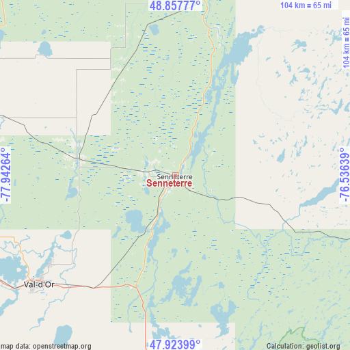
Senneterre GPS coordinates[2]
48° 23' 34.872" North, 77° 14' 22.236" West
| Map corner | latitude | longitude |
|---|---|---|
| Upper-left | 48.85777°, | -77.94264° |
| Center: | 48.39302°, | -77.23951° |
| Lower-right: | 47.92399°, | -76.53639° |
| Map W x H: | 103.8×103.8 km | = 64.5×64.5mi |
| max Lat: | 73.03752° ⇑43.5% North |
| Senneterre: | 48.39302° |
| min Lat: | ⇓56.5% South 42.05009° |
| min Long | Senneterre | max Long |
| -139.43328° | -77.23951° | -52.70931° |
| W 52.9%⇐ | ⇒47.1% E |
Elevation
Elevation of Senneterre is 314 m = 1030 ft, and this is 59.6 m = 196 ft above average elevation for this country.
| Max E: |
1518 m = 4980 ft | 28.8% |
| Senneterre | 314 m 1030 ft | |
| Avg. | 254.4 m = 835 ft | |
Min E: |
-2 m = -7 ft | 71.2% |
See also: Canada elevation on elevation.city.
Geographical zone
Senneterre is located in North temperate zone (between Tropic of Cancer and the Arctic Circle). Distance of this North polar circle is 2020.4 km =1255.4 mi to North.| Distance of | km | miles | from Senneterre |
|---|---|---|---|
| North Pole | 4626.3 | 2874.6 | to North |
| Arctic Circle | 2020.4 | 1255.4 | to North |
| Tropic Cancer | 2774.9 | 1724.2 | to South |
| Equator | 5380.8 | 3343.5 | to South |


Nearby cities:
15 places around Senneterre: (largest is in red/bold)
• Amos
67.4 km =41.9 mi,  286°
286°
• Barraute
29.4 km =18.3 mi,  278°
278°
• Englehart
205.3 km =127.6 mi,  251°
251°
• Kirkland Lake
208.9 km =129.8 mi,  262°
262°
• La Sarre
151.1 km =93.9 mi, 287°
• Lebel-sur-Quévillon
75.5 km =46.9 mi,  14°
14°
• Macamic
135.4 km =84.1 mi, 287°
• Malartic
72.1 km =44.8 mi, 246°
• Matagami
153.6 km =95.4 mi,  349°
349°
• Rouyn-Noranda
133 km =82.6 mi, 262°
• Saint-Bruno-de-Guigues
193.1 km =120 mi,  237°
237°
• Saint-Isidore
187 km =116.2 mi, 235°
• Val-d'Or
52.8 km =32.8 mi,  231°
231°
• Ville-Marie
201.6 km =125.3 mi, 234°
• Waswanipi
168.3 km =104.6 mi,  27°
27°
Sources, notices
• [Note1] Compared only with cities in Canada existing in our database
• [Src1] Map data: © OpenStreetMap contributors (CC-BY-SA)
• [Src2] Other city data from geonames.org with taken over terms of usage.
• [Src3] Geographical zone / Annual Mean Temperature by Robert A. Rohde @ Wikipedia
