Val-d'Or geodata
Val-d'Or (Quebec) is a populated place; located in Canada in America/Toronto (GMT-4) time zone. With population of 25,541 people, there are 158 cities with bigger population in this country. Compared to other cities in Canada, 54.5% of cities are located further ↓South; 52% of cities are located further ←West and 73.1% of cities have lower elevation than Val-d'Or. Note1


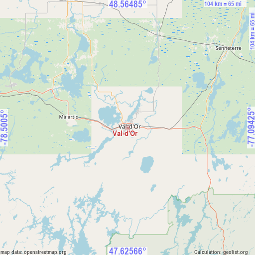
Val-d'Or GPS coordinates[2]
48° 5' 50.64" North, 77° 47' 50.532" West
| Map corner | latitude | longitude |
|---|---|---|
| Upper-left | 48.56485°, | -78.5005° |
| Center: | 48.0974°, | -77.79737° |
| Lower-right: | 47.62566°, | -77.09425° |
| Map W x H: | 104.4×104.4 km | = 64.9×64.9mi |
| max Lat: | 73.03752° ⇑45.5% North |
| Val-d'Or: | 48.0974° |
| min Lat: | ⇓54.5% South 42.05009° |
| min Long | Val-d'Or | max Long |
| -139.43328° | -77.79737° | -52.70931° |
| W 52%⇐ | ⇒48% E |
Elevation
Elevation of Val-d'Or is 338 m = 1109 ft, and this is 83.6 m = 274 ft above average elevation for this country.
| Max E: |
1518 m = 4980 ft | 26.9% |
| Val-d'Or | 338 m 1109 ft | |
| Avg. | 254.4 m = 835 ft | |
Min E: |
-2 m = -7 ft | 73.1% |
See also: Canada elevation on elevation.city.
Geographical zone
Val-d'Or is located in North temperate zone (between Tropic of Cancer and the Arctic Circle). Distance of this North polar circle is 2053.2 km =1275.8 mi to North.| Distance of | km | miles | from Val-d'Or |
|---|---|---|---|
| North Pole | 4659.1 | 2895 | to North |
| Arctic Circle | 2053.2 | 1275.8 | to North |
| Tropic Cancer | 2742 | 1703.8 | to South |
| Equator | 5347.9 | 3323 | to South |


Nearby cities:
15 places around Val-d'Or: (largest is in red/bold)
• Amos
57.3 km =35.6 mi,  335°
335°
• Barraute
39.3 km =24.4 mi,  18°
18°
• Englehart
157.2 km =97.7 mi,  258°
258°
• Kirkland Lake
166.4 km =103.4 mi,  271°
271°
• La Sarre
129.6 km =80.5 mi,  307°
307°
• Lebel-sur-Quévillon
121.7 km =75.6 mi,  29°
29°
• Macamic
114.6 km =71.2 mi, 309°
• Malartic
25.2 km =15.7 mi,  279°
279°
• Notre-Dame-du-Lac
177 km =110 mi,  212°
212°
• Rouyn-Noranda
92.2 km =57.3 mi, 279°
• Saint-Bruno-de-Guigues
140.9 km =87.6 mi,  240°
240°
• Saint-Isidore
134.4 km =83.5 mi, 236°
• Senneterre
52.8 km =32.8 mi,  51°
51°
• Temiskaming Shores
158.2 km =98.3 mi, 244°
• Ville-Marie
148.9 km =92.5 mi, 235°
Sources, notices
• [Note1] Compared only with cities in Canada existing in our database
• [Src1] Map data: © OpenStreetMap contributors (CC-BY-SA)
• [Src2] Other city data from geonames.org with taken over terms of usage.
• [Src3] Geographical zone / Annual Mean Temperature by Robert A. Rohde @ Wikipedia
