Seaforth geodata
Seaforth (Ontario) is a populated place; located in Canada in America/Toronto (GMT-4) time zone. With population of 2,680 people, there are 652 cities with bigger population in this country. Compared to other cities in Canada, 94.4% of cities are located further ↑North; 60.6% of cities are located further →East and 70.5% of cities have lower elevation than Seaforth. Note1


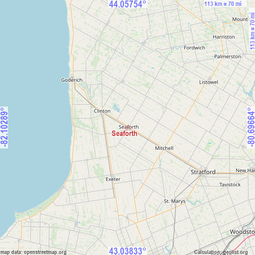
Seaforth GPS coordinates[2]
43° 33' 0.324" North, 81° 23' 59.136" West
| Map corner | latitude | longitude |
|---|---|---|
| Upper-left | 44.05754°, | -82.10289° |
| Center: | 43.55009°, | -81.39976° |
| Lower-right: | 43.03833°, | -80.69664° |
| Map W x H: | 113.3×113.3 km | = 70.4×70.4mi |
| max Lat: | 73.03752° ⇑94.4% North |
| Seaforth: | 43.55009° |
| min Lat: | ⇓5.6% South 42.05009° |
| min Long | Seaforth | max Long |
| -139.43328° | -81.39976° | -52.70931° |
| W 39.4%⇐ | ⇒60.6% E |
Elevation
Elevation of Seaforth is 308 m = 1010 ft, and this is 53.6 m = 176 ft above average elevation for this country.
| Max E: |
1518 m = 4980 ft | 29.5% |
| Seaforth | 308 m 1010 ft | |
| Avg. | 254.4 m = 835 ft | |
Min E: |
-2 m = -7 ft | 70.5% |
See also: Canada elevation on elevation.city.
Geographical zone
Seaforth is located in North temperate zone (between Tropic of Cancer and the Arctic Circle). Distance of this Northern Tropic circle is 2236.4 km =1389.6 mi to South.| Distance of | km | miles | from Seaforth |
|---|---|---|---|
| North Pole | 5164.7 | 3209.2 | to North |
| Arctic Circle | 2558.9 | 1590 | to North |
| Tropic Cancer | 2236.4 | 1389.6 | to South |
| Equator | 4842.3 | 3008.9 | to South |


Nearby cities:
15 places around Seaforth: (largest is in red/bold)
• Bluewater
18.6 km =11.6 mi,  240°
240°
• Brussels
23.7 km =14.7 mi,  30°
30°
• Goderich
33 km =20.5 mi,  310°
310°
• Harriston
56.9 km =35.4 mi,  46°
46°
• Huron East
10.9 km =6.8 mi, 47°
• Linwood
54.2 km =33.7 mi,  86°
86°
• Listowel
41.6 km =25.8 mi,  60°
60°
• Lucan
40.8 km =25.4 mi,  180°
180°
• North Perth
39.9 km =24.8 mi, 60°
• Parkhill
49.1 km =30.5 mi,  207°
207°
• South Huron
27.6 km =17.1 mi,  199°
199°
• Stratford
41.6 km =25.8 mi,  119°
119°
• Tavistock
52.6 km =32.7 mi, 119°
• Wellesley
52.1 km =32.4 mi,  98°
98°
• Wingham
38.2 km =23.7 mi,  10°
10°
Sources, notices
• [Note1] Compared only with cities in Canada existing in our database
• [Src1] Map data: © OpenStreetMap contributors (CC-BY-SA)
• [Src2] Other city data from geonames.org with taken over terms of usage.
• [Src3] Geographical zone / Annual Mean Temperature by Robert A. Rohde @ Wikipedia
