Vauxhall geodata
Vauxhall (Alberta) is a populated place; located in Canada in America/Edmonton (GMT-6) time zone. With population of 1,222 people, there are 944 cities with bigger population in this country. Compared to other cities in Canada, 76.4% of cities are located further ↓South; 76.7% of cities are located further →East and 94.4% of cities have lower elevation than Vauxhall. Note1


Vauxhall GPS coordinates[2]
50° 4' 0.408" North, 112° 7' 6.708" West
| Map corner | latitude | longitude |
|---|---|---|
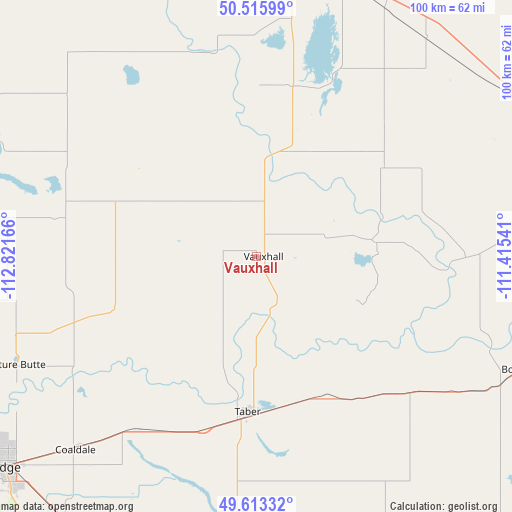
| Upper-left | 50.51599°, | -112.82166° |
| Center: | 50.06678°, | -112.11853° |
| Lower-right: | 49.61332°, | -111.41541° |
| Map W x H: | 100.4×100.4 km | = 62.4×62.4mi |
| max Lat: | 73.03752° ⇑23.6% North |
| Vauxhall: | 50.06678° |
| min Lat: | ⇓76.4% South 42.05009° |
| min Long | Vauxhall | max Long |
| -139.43328° | -112.11853° | -52.70931° |
| W 23.3%⇐ | ⇒76.7% E |
Elevation
Elevation of Vauxhall is 780 m = 2559 ft, and this is 525.6 m = 1724 ft above average elevation for this country.
| Max E: |
1518 m = 4980 ft | 5.6% |
| Vauxhall | 780 m 2559 ft | |
| Avg. | 254.4 m = 835 ft | |
Min E: |
-2 m = -7 ft | 94.4% |
See also: Canada elevation on elevation.city.
Geographical zone
Vauxhall is located in North temperate zone (between Tropic of Cancer and the Arctic Circle). Distance of this North polar circle is 1834.3 km =1139.8 mi to North.| Distance of | km | miles | from Vauxhall |
|---|---|---|---|
| North Pole | 4440.2 | 2759 | to North |
| Arctic Circle | 1834.3 | 1139.8 | to North |
| Tropic Cancer | 2961 | 1839.9 | to South |
| Equator | 5566.9 | 3459.1 | to South |


Nearby cities:
15 places around Vauxhall: (largest is in red/bold)
• Bassano
83.5 km =51.9 mi,  342°
342°
• Bow Island
58.1 km =36.1 mi,  112°
112°
• Brooks
59.8 km =37.2 mi,  16°
16°
• Claresholm
104.8 km =65.1 mi,  267°
267°
• Coaldale
52.9 km =32.9 mi,  222°
222°
• Coalhurst
68.3 km =42.4 mi,  238°
238°
• Fort Macleod
100.9 km =62.7 mi,  247°
247°
• Lethbridge
64.6 km =40.1 mi,  230°
230°
• Magrath
90.2 km =56 mi, 216°
• Medicine Hat
103 km =64 mi,  91°
91°
• Nanton
121.6 km =75.6 mi,  285°
285°
• Picture Butte
51.9 km =32.2 mi, 246°
• Raymond
78.6 km =48.8 mi,  209°
209°
• Taber
31.2 km =19.4 mi,  183°
183°
• Vulcan
88.7 km =55.1 mi, 294°
Sources, notices
• [Note1] Compared only with cities in Canada existing in our database
• [Src1] Map data: © OpenStreetMap contributors (CC-BY-SA)
• [Src2] Other city data from geonames.org with taken over terms of usage.
• [Src3] Geographical zone / Annual Mean Temperature by Robert A. Rohde @ Wikipedia
