Taber geodata
Taber (Alberta) is a populated place; located in Canada in America/Edmonton (GMT-6) time zone. With population of 8,163 people, there are 358 cities with bigger population in this country. Compared to other cities in Canada, 73.8% of cities are located further ↓South; 76.8% of cities are located further →East and 94.9% of cities have lower elevation than Taber. Note1


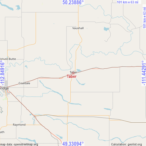
Taber GPS coordinates[2]
49° 47' 13.308" North, 112° 8' 45.708" West
| Map corner | latitude | longitude |
|---|---|---|
| Upper-left | 50.23886°, | -112.84916° |
| Center: | 49.78703°, | -112.14603° |
| Lower-right: | 49.33094°, | -111.44291° |
| Map W x H: | 101×100.9 km | = 62.8×62.7mi |
| max Lat: | 73.03752° ⇑26.2% North |
| Taber: | 49.78703° |
| min Lat: | ⇓73.8% South 42.05009° |
| min Long | Taber | max Long |
| -139.43328° | -112.14603° | -52.70931° |
| W 23.2%⇐ | ⇒76.8% E |
Elevation
Elevation of Taber is 813 m = 2667 ft, and this is 558.6 m = 1833 ft above average elevation for this country.
| Max E: |
1518 m = 4980 ft | 5.1% |
| Taber | 813 m 2667 ft | |
| Avg. | 254.4 m = 835 ft | |
Min E: |
-2 m = -7 ft | 94.9% |
See also: Canada elevation on elevation.city.
Geographical zone
Taber is located in North temperate zone (between Tropic of Cancer and the Arctic Circle). Distance of this North polar circle is 1865.4 km =1159.1 mi to North.| Distance of | km | miles | from Taber |
|---|---|---|---|
| North Pole | 4471.3 | 2778.3 | to North |
| Arctic Circle | 1865.4 | 1159.1 | to North |
| Tropic Cancer | 2929.9 | 1820.6 | to South |
| Equator | 5535.8 | 3439.8 | to South |


Nearby cities:
15 places around Taber: (largest is in red/bold)
• Bassano
113.1 km =70.3 mi,  348°
348°
• Bow Island
56.5 km =35.1 mi,  80°
80°
• Brooks
90.5 km =56.2 mi,  11°
11°
• Cardston
106 km =65.9 mi,  231°
231°
• Claresholm
106.6 km =66.2 mi,  284°
284°
• Coaldale
34.8 km =21.6 mi,  257°
257°
• Coalhurst
56.7 km =35.2 mi,  265°
265°
• Fort Macleod
91.8 km =57 mi, 265°
• Lethbridge
49.3 km =30.6 mi, 258°
• Magrath
66.4 km =41.3 mi, 231°
• Medicine Hat
108.9 km =67.7 mi, 75°
• Picture Butte
47.1 km =29.3 mi, 283°
• Raymond
52.3 km =32.5 mi,  224°
224°
• Vauxhall
31.2 km =19.4 mi,  3°
3°
• Vulcan
104.3 km =64.8 mi,  310°
310°
Sources, notices
• [Note1] Compared only with cities in Canada existing in our database
• [Src1] Map data: © OpenStreetMap contributors (CC-BY-SA)
• [Src2] Other city data from geonames.org with taken over terms of usage.
• [Src3] Geographical zone / Annual Mean Temperature by Robert A. Rohde @ Wikipedia
