Coaldale geodata
Coaldale (Alberta) is a populated place; located in Canada in America/Edmonton (GMT-6) time zone. With population of 6,317 people, there are 420 cities with bigger population in this country. Compared to other cities in Canada, 72.8% of cities are located further ↓South; 77% of cities are located further →East and 95.6% of cities have lower elevation than Coaldale. Note1


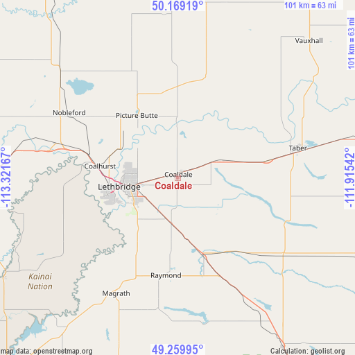
Coaldale GPS coordinates[2]
49° 43' 0.12" North, 112° 37' 6.744" West
| Map corner | latitude | longitude |
|---|---|---|
| Upper-left | 50.16919°, | -113.32167° |
| Center: | 49.7167°, | -112.61854° |
| Lower-right: | 49.25995°, | -111.91542° |
| Map W x H: | 101.1×101.1 km | = 62.8×62.8mi |
| max Lat: | 73.03752° ⇑27.2% North |
| Coaldale: | 49.7167° |
| min Lat: | ⇓72.8% South 42.05009° |
| min Long | Coaldale | max Long |
| -139.43328° | -112.61854° | -52.70931° |
| W 23%⇐ | ⇒77% E |
Elevation
Elevation of Coaldale is 865 m = 2838 ft, and this is 610.6 m = 2003 ft above average elevation for this country.
| Max E: |
1518 m = 4980 ft | 4.4% |
| Coaldale | 865 m 2838 ft | |
| Avg. | 254.4 m = 835 ft | |
Min E: |
-2 m = -7 ft | 95.6% |
See also: Canada elevation on elevation.city.
Geographical zone
Coaldale is located in North temperate zone (between Tropic of Cancer and the Arctic Circle). Distance of this North polar circle is 1873.2 km =1164 mi to North.| Distance of | km | miles | from Coaldale |
|---|---|---|---|
| North Pole | 4479.1 | 2783.2 | to North |
| Arctic Circle | 1873.2 | 1164 | to North |
| Tropic Cancer | 2922.1 | 1815.7 | to South |
| Equator | 5528 | 3434.9 | to South |


Nearby cities:
15 places around Coaldale: (largest is in red/bold)
• Bow Island
91.3 km =56.7 mi,  79°
79°
• Brooks
109.6 km =68.1 mi,  28°
28°
• Cardston
75.8 km =47.1 mi,  220°
220°
• Claresholm
77.7 km =48.3 mi,  296°
296°
• Coalhurst
22.8 km =14.2 mi,  278°
278°
• Fort Macleod
57.5 km =35.7 mi,  270°
270°
• Lethbridge
14.5 km =9 mi,  262°
262°
• Magrath
37.9 km =23.5 mi,  208°
208°
• Nanton
108.2 km =67.2 mi,  310°
310°
• Picture Butte
22 km =13.7 mi,  327°
327°
• Pincher Creek
99.5 km =61.8 mi,  254°
254°
• Raymond
29.8 km =18.5 mi,  184°
184°
• Taber
34.8 km =21.6 mi, 77°
• Vauxhall
52.9 km =32.9 mi,  42°
42°
• Vulcan
88.4 km =54.9 mi, 329°
Sources, notices
• [Note1] Compared only with cities in Canada existing in our database
• [Src1] Map data: © OpenStreetMap contributors (CC-BY-SA)
• [Src2] Other city data from geonames.org with taken over terms of usage.
• [Src3] Geographical zone / Annual Mean Temperature by Robert A. Rohde @ Wikipedia
