Pembroke geodata
Pembroke (Ontario) is a populated place; located in Canada in America/Toronto (GMT-4) time zone. With population of 15,551 people, there are 238 cities with bigger population in this country. Compared to other cities in Canada, 67.6% of cities are located further ↑North; 53.1% of cities are located further ←West and 57.2% of cities have higher elevation than Pembroke. Note1


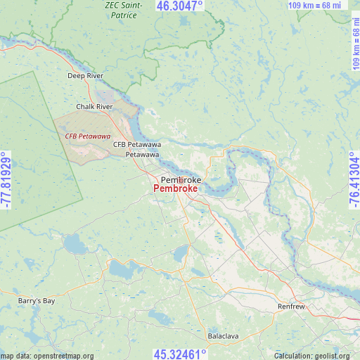
Pembroke GPS coordinates[2]
45° 49' 0.516" North, 77° 6' 58.176" West
| Map corner | latitude | longitude |
|---|---|---|
| Upper-left | 46.3047°, | -77.81929° |
| Center: | 45.81681°, | -77.11616° |
| Lower-right: | 45.32461°, | -76.41304° |
| Map W x H: | 109×109 km | = 67.7×67.7mi |
| max Lat: | 73.03752° ⇑67.6% North |
| Pembroke: | 45.81681° |
| min Lat: | ⇓32.4% South 42.05009° |
| min Long | Pembroke | max Long |
| -139.43328° | -77.11616° | -52.70931° |
| W 53.1%⇐ | ⇒46.9% E |
Elevation
Elevation of Pembroke is 120 m = 394 ft, and this is 134.4 m = 441 ft below average elevation for this country.
| Max E: |
1518 m = 4980 ft | 57.2% |
| Avg. | 254.4 m = 835 ft | |
| Pembroke | 120 m = 394 ft | |
Min E: |
-2 m = -7 ft | 42.8% |
See also: Canada elevation on elevation.city.
Geographical zone
Pembroke is located in North temperate zone (between Tropic of Cancer and the Arctic Circle). Distance of this North polar circle is 2306.8 km =1433.4 mi to North.| Distance of | km | miles | from Pembroke |
|---|---|---|---|
| North Pole | 4912.7 | 3052.6 | to North |
| Arctic Circle | 2306.8 | 1433.4 | to North |
| Tropic Cancer | 2488.4 | 1546.2 | to South |
| Equator | 5094.4 | 3165.5 | to South |


Nearby cities:
15 places around Pembroke: (largest is in red/bold)
• Arnprior
73.3 km =45.5 mi,  125°
125°
• Bancroft
102.3 km =63.6 mi,  214°
214°
• Cantley
107.2 km =66.6 mi,  105°
105°
• Carleton Place
107 km =66.5 mi,  135°
135°
• Constance Bay
87.7 km =54.5 mi, 113°
• Deep River
43.2 km =26.8 mi,  316°
316°
• Fort-Coulonge
29.9 km =18.6 mi,  82°
82°
• Kanata
109.7 km =68.2 mi,  121°
121°
• Kazabazua
86.4 km =53.7 mi, 80°
• Maniwaki
108.8 km =67.6 mi,  54°
54°
• Petawawa
15.4 km =9.6 mi,  304°
304°
• Renfrew
51.5 km =32 mi, 139°
• Saint-Raphaël
97.6 km =60.6 mi,  60°
60°
• Shawville
54.8 km =34.1 mi, 116°
• Wakefield
101 km =62.8 mi,  99°
99°
Sources, notices
• [Note1] Compared only with cities in Canada existing in our database
• [Src1] Map data: © OpenStreetMap contributors (CC-BY-SA)
• [Src2] Other city data from geonames.org with taken over terms of usage.
• [Src3] Geographical zone / Annual Mean Temperature by Robert A. Rohde @ Wikipedia
