Kazabazua geodata
Kazabazua (Quebec) is a populated place; located in Canada in America/Toronto (GMT-4) time zone. With population of 847 people, there are 1088 cities with bigger population in this country. Compared to other cities in Canada, 64.3% of cities are located further ↑North; 54.7% of cities are located further ←West and 52.1% of cities have lower elevation than Kazabazua. Note1


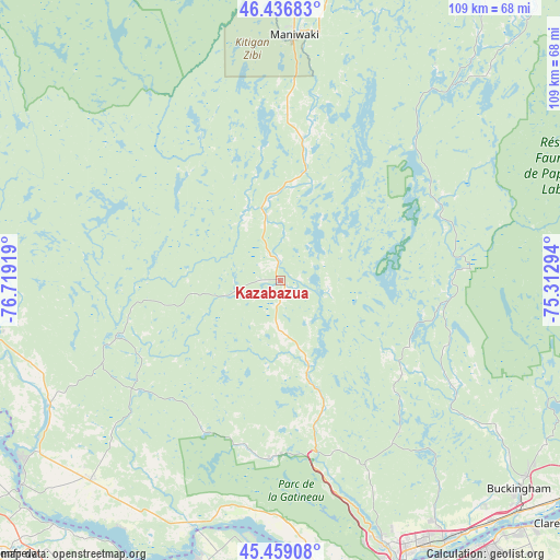
Kazabazua GPS coordinates[2]
45° 57' 0.396" North, 76° 0' 57.816" West
| Map corner | latitude | longitude |
|---|---|---|
| Upper-left | 46.43683°, | -76.71919° |
| Center: | 45.95011°, | -76.01606° |
| Lower-right: | 45.45908°, | -75.31294° |
| Map W x H: | 108.7×108.7 km | = 67.5×67.5mi |
| max Lat: | 73.03752° ⇑64.3% North |
| Kazabazua: | 45.95011° |
| min Lat: | ⇓35.7% South 42.05009° |
| min Long | Kazabazua | max Long |
| -139.43328° | -76.01606° | -52.70931° |
| W 54.7%⇐ | ⇒45.3% E |
Elevation
Elevation of Kazabazua is 183 m = 600 ft, and this is 71.4 m = 234 ft below average elevation for this country.
| Max E: |
1518 m = 4980 ft | 47.9% |
| Avg. | 254.4 m = 835 ft | |
| Kazabazua | 183 m = 600 ft | |
Min E: |
-2 m = -7 ft | 52.1% |
See also: Canada elevation on elevation.city.
Geographical zone
Kazabazua is located in North temperate zone (between Tropic of Cancer and the Arctic Circle). Distance of this North polar circle is 2292 km =1424.2 mi to North.| Distance of | km | miles | from Kazabazua |
|---|---|---|---|
| North Pole | 4897.9 | 3043.4 | to North |
| Arctic Circle | 2292 | 1424.2 | to North |
| Tropic Cancer | 2503.3 | 1555.5 | to South |
| Equator | 5109.2 | 3174.7 | to South |


Nearby cities:
15 places around Kazabazua: (largest is in red/bold)
• Arnprior
63 km =39.1 mi,  204°
204°
• Buckingham
61.4 km =38.2 mi,  131°
131°
• Cantley
46.3 km =28.8 mi,  156°
156°
• Constance Bay
50.3 km =31.3 mi,  185°
185°
• Fort-Coulonge
56.6 km =35.2 mi,  258°
258°
• Gatineau
58 km =36 mi, 155°
• Maniwaki
48.3 km =30 mi,  4°
4°
• Saint-Alexandre
54.2 km =33.7 mi, 157°
• Saint-Boniface
61.2 km =38 mi, 2°
• Saint-Raphaël
33.4 km =20.8 mi, 0°
• Shawville
53.1 km =33 mi,  222°
222°
• Val-des-Monts
43 km =26.7 mi,  140°
140°
• Vanier
62.9 km =39.1 mi,  154°
154°
• Wakefield
34.6 km =21.5 mi, 155°
• le Plateau
60.1 km =37.3 mi, 162°
Sources, notices
• [Note1] Compared only with cities in Canada existing in our database
• [Src1] Map data: © OpenStreetMap contributors (CC-BY-SA)
• [Src2] Other city data from geonames.org with taken over terms of usage.
• [Src3] Geographical zone / Annual Mean Temperature by Robert A. Rohde @ Wikipedia
