Maniwaki geodata
Maniwaki (Quebec) is a populated place; located in Canada in America/Toronto (GMT-4) time zone. With population of 4,236 people, there are 514 cities with bigger population in this country. Compared to other cities in Canada, 56.3% of cities are located further ↑North; 55% of cities are located further ←West and 51.4% of cities have higher elevation than Maniwaki. Note1


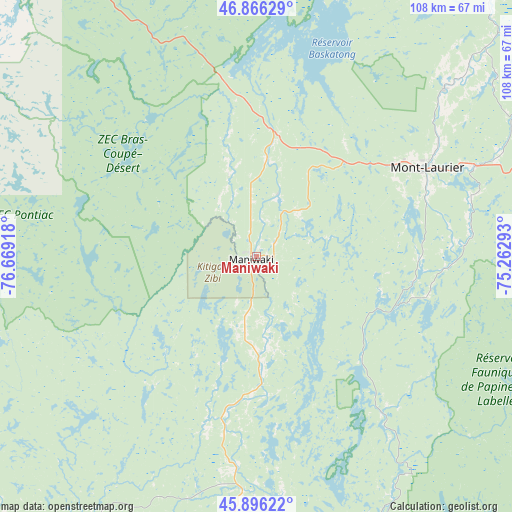
Maniwaki GPS coordinates[2]
46° 23' 0.276" North, 75° 57' 57.78" West
| Map corner | latitude | longitude |
|---|---|---|
| Upper-left | 46.86629°, | -76.66918° |
| Center: | 46.38341°, | -75.96605° |
| Lower-right: | 45.89622°, | -75.26293° |
| Map W x H: | 107.9×107.9 km | = 67×67mi |
| max Lat: | 73.03752° ⇑56.3% North |
| Maniwaki: | 46.38341° |
| min Lat: | ⇓43.7% South 42.05009° |
| min Long | Maniwaki | max Long |
| -139.43328° | -75.96605° | -52.70931° |
| W 55%⇐ | ⇒45% E |
Elevation
Elevation of Maniwaki is 162 m = 531 ft, and this is 92.4 m = 303 ft below average elevation for this country.
| Max E: |
1518 m = 4980 ft | 51.4% |
| Avg. | 254.4 m = 835 ft | |
| Maniwaki | 162 m = 531 ft | |
Min E: |
-2 m = -7 ft | 48.6% |
See also: Canada elevation on elevation.city.
Geographical zone
Maniwaki is located in North temperate zone (between Tropic of Cancer and the Arctic Circle). Distance of this North polar circle is 2243.8 km =1394.2 mi to North.| Distance of | km | miles | from Maniwaki |
|---|---|---|---|
| North Pole | 4849.7 | 3013.5 | to North |
| Arctic Circle | 2243.8 | 1394.2 | to North |
| Tropic Cancer | 2551.4 | 1585.4 | to South |
| Equator | 5157.4 | 3204.7 | to South |


Nearby cities:
15 places around Maniwaki: (largest is in red/bold)
• Cantley
91.9 km =57.1 mi,  171°
171°
• Ferme-Neuve
52.9 km =32.9 mi,  48°
48°
• Fort-Coulonge
83.7 km =52 mi,  224°
224°
• Kazabazua
48.3 km =30 mi,  184°
184°
• La Minerve
80.7 km =50.1 mi,  100°
100°
• Labelle
95.3 km =59.2 mi, 96°
• Mont-Laurier
40.3 km =25 mi,  62°
62°
• Notre-Dame-du-Mont-Carmel
79.3 km =49.3 mi,  120°
120°
• Rivière-Rouge
84.4 km =52.4 mi,  87°
87°
• Saint-Boniface
13 km =8.1 mi,  354°
354°
• Saint-Raphaël
15.3 km =9.5 mi,  194°
194°
• Saint-Émile-de-Suffolk
95.1 km =59.1 mi, 121°
• Shawville
95.8 km =59.5 mi,  204°
204°
• Val-des-Monts
84.8 km =52.7 mi,  164°
164°
• Wakefield
80.3 km =49.9 mi, 172°
Sources, notices
• [Note1] Compared only with cities in Canada existing in our database
• [Src1] Map data: © OpenStreetMap contributors (CC-BY-SA)
• [Src2] Other city data from geonames.org with taken over terms of usage.
• [Src3] Geographical zone / Annual Mean Temperature by Robert A. Rohde @ Wikipedia
