Bancroft geodata
Bancroft (Ontario) is a populated place; located in Canada in America/Toronto (GMT-4) time zone. With population of 3,838 people, there are 545 cities with bigger population in this country. Compared to other cities in Canada, 84.1% of cities are located further ↑North; 51.9% of cities are located further ←West and 72.1% of cities have lower elevation than Bancroft. Note1


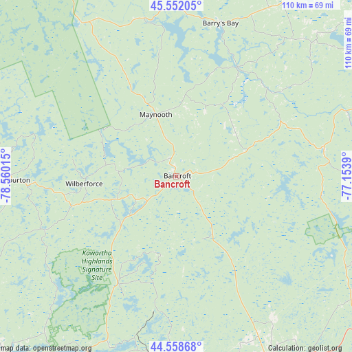
Bancroft GPS coordinates[2]
45° 3' 27.072" North, 77° 51' 25.272" West
| Map corner | latitude | longitude |
|---|---|---|
| Upper-left | 45.55205°, | -78.56015° |
| Center: | 45.05752°, | -77.85702° |
| Lower-right: | 44.55868°, | -77.1539° |
| Map W x H: | 110.5×110.5 km | = 68.7×68.7mi |
| max Lat: | 73.03752° ⇑84.1% North |
| Bancroft: | 45.05752° |
| min Lat: | ⇓15.9% South 42.05009° |
| min Long | Bancroft | max Long |
| -139.43328° | -77.85702° | -52.70931° |
| W 51.9%⇐ | ⇒48.1% E |
Elevation
Elevation of Bancroft is 330 m = 1083 ft, and this is 75.6 m = 248 ft above average elevation for this country.
| Max E: |
1518 m = 4980 ft | 27.9% |
| Bancroft | 330 m 1083 ft | |
| Avg. | 254.4 m = 835 ft | |
Min E: |
-2 m = -7 ft | 72.1% |
See also: Canada elevation on elevation.city.
Geographical zone
Bancroft is located in North temperate zone (between Tropic of Cancer and the Arctic Circle). Distance of this North polar circle is 2391.2 km =1485.8 mi to North.| Distance of | km | miles | from Bancroft |
|---|---|---|---|
| North Pole | 4997.1 | 3105.1 | to North |
| Arctic Circle | 2391.2 | 1485.8 | to North |
| Tropic Cancer | 2404 | 1493.8 | to South |
| Equator | 5009.9 | 3113 | to South |


Nearby cities:
15 places around Bancroft: (largest is in red/bold)
• Belleville
105.9 km =65.8 mi,  159°
159°
• Haliburton Village
52.3 km =32.5 mi,  269°
269°
• Huntsville
110.8 km =68.8 mi,  286°
286°
• Lakefield
76.5 km =47.5 mi,  204°
204°
• Lindsay
104.8 km =65.1 mi,  221°
221°
• Madoc
68.1 km =42.3 mi,  153°
153°
• Norwood
75.6 km =47 mi,  187°
187°
• Omemee
101 km =62.8 mi,  213°
213°
• Pembroke
102.3 km =63.6 mi,  34°
34°
• Petawawa
103.4 km =64.2 mi, 25°
• Peterborough
91.7 km =57 mi, 203°
• Quinte West
99.9 km =62.1 mi,  166°
166°
• Renfrew
102.6 km =63.8 mi,  63°
63°
• Stirling
87.7 km =54.5 mi, 163°
• Tweed
77.6 km =48.2 mi, 146°
Sources, notices
• [Note1] Compared only with cities in Canada existing in our database
• [Src1] Map data: © OpenStreetMap contributors (CC-BY-SA)
• [Src2] Other city data from geonames.org with taken over terms of usage.
• [Src3] Geographical zone / Annual Mean Temperature by Robert A. Rohde @ Wikipedia
