Petawawa geodata
Petawawa (Ontario) is a populated place; located in Canada in America/Toronto (GMT-4) time zone. With population of 15,988 people, there are 227 cities with bigger population in this country. Compared to other cities in Canada, 65.9% of cities are located further ↑North; 52.8% of cities are located further ←West and 54.5% of cities have higher elevation than Petawawa. Note1


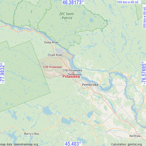
Petawawa GPS coordinates[2]
45° 53' 40.272" North, 77° 16' 48.252" West
| Map corner | latitude | longitude |
|---|---|---|
| Upper-left | 46.38173°, | -77.9832° |
| Center: | 45.89452°, | -77.28007° |
| Lower-right: | 45.403°, | -76.57695° |
| Map W x H: | 108.8×108.8 km | = 67.6×67.6mi |
| max Lat: | 73.03752° ⇑65.9% North |
| Petawawa: | 45.89452° |
| min Lat: | ⇓34.1% South 42.05009° |
| min Long | Petawawa | max Long |
| -139.43328° | -77.28007° | -52.70931° |
| W 52.8%⇐ | ⇒47.2% E |
Elevation
Elevation of Petawawa is 143 m = 469 ft, and this is 111.4 m = 365 ft below average elevation for this country.
| Max E: |
1518 m = 4980 ft | 54.5% |
| Avg. | 254.4 m = 835 ft | |
| Petawawa | 143 m = 469 ft | |
Min E: |
-2 m = -7 ft | 45.5% |
See also: Canada elevation on elevation.city.
Geographical zone
Petawawa is located in North temperate zone (between Tropic of Cancer and the Arctic Circle). Distance of this North polar circle is 2298.2 km =1428 mi to North.| Distance of | km | miles | from Petawawa |
|---|---|---|---|
| North Pole | 4904.1 | 3047.3 | to North |
| Arctic Circle | 2298.2 | 1428 | to North |
| Tropic Cancer | 2497.1 | 1551.6 | to South |
| Equator | 5103 | 3170.9 | to South |


Nearby cities:
15 places around Petawawa: (largest is in red/bold)
• Arnprior
88.6 km =55.1 mi,  125°
125°
• Bancroft
103.4 km =64.2 mi,  205°
205°
• Cantley
121.8 km =75.7 mi,  107°
107°
• Constance Bay
102.8 km =63.9 mi,  115°
115°
• Deep River
28.5 km =17.7 mi,  323°
323°
• Fort-Coulonge
42.7 km =26.5 mi,  96°
96°
• Kazabazua
98 km =60.9 mi,  86°
86°
• Maniwaki
114.9 km =71.4 mi,  61°
61°
• Mattawa
119.1 km =74 mi,  293°
293°
• Pembroke
15.4 km =9.6 mi, 124°
• Renfrew
66.4 km =41.3 mi,  135°
135°
• Saint-Boniface
120.4 km =74.8 mi, 56°
• Saint-Raphaël
105.2 km =65.4 mi,  67°
67°
• Shawville
70 km =43.5 mi, 117°
• Wakefield
115.1 km =71.5 mi, 102°
Sources, notices
• [Note1] Compared only with cities in Canada existing in our database
• [Src1] Map data: © OpenStreetMap contributors (CC-BY-SA)
• [Src2] Other city data from geonames.org with taken over terms of usage.
• [Src3] Geographical zone / Annual Mean Temperature by Robert A. Rohde @ Wikipedia
