Saint-Raphaël geodata
Saint-Raphaël (Quebec) is a populated place; located in Canada in America/Toronto (GMT-4) time zone. With population of 1,113 people, there are 994 cities with bigger population in this country. Compared to other cities in Canada, 58.2% of cities are located further ↑North; 54.8% of cities are located further ←West and 51.6% of cities have lower elevation than Saint-Raphaël. Note1


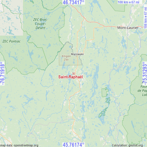
Saint-Raphaël GPS coordinates[2]
46° 15' 0.396" North, 76° 0' 57.78" West
| Map corner | latitude | longitude |
|---|---|---|
| Upper-left | 46.73417°, | -76.71918° |
| Center: | 46.25011°, | -76.01605° |
| Lower-right: | 45.76174°, | -75.31293° |
| Map W x H: | 108.1×108.1 km | = 67.2×67.2mi |
| max Lat: | 73.03752° ⇑58.2% North |
| Saint-Raphaël: | 46.25011° |
| min Lat: | ⇓41.8% South 42.05009° |
| min Long | Saint-Raphaël | max Long |
| -139.43328° | -76.01605° | -52.70931° |
| W 54.8%⇐ | ⇒45.2% E |
Elevation
Elevation of Saint-Raphaël is 179 m = 587 ft, and this is 75.4 m = 247 ft below average elevation for this country.
| Max E: |
1518 m = 4980 ft | 48.4% |
| Avg. | 254.4 m = 835 ft | |
| Saint-Raphaël | 179 m = 587 ft | |
Min E: |
-2 m = -7 ft | 51.6% |
See also: Canada elevation on elevation.city.
Geographical zone
Saint-Raphaël is located in North temperate zone (between Tropic of Cancer and the Arctic Circle). Distance of this North polar circle is 2258.6 km =1403.4 mi to North.| Distance of | km | miles | from Saint-Raphaël |
|---|---|---|---|
| North Pole | 4864.5 | 3022.7 | to North |
| Arctic Circle | 2258.6 | 1403.4 | to North |
| Tropic Cancer | 2536.6 | 1576.2 | to South |
| Equator | 5142.5 | 3195.4 | to South |


Nearby cities:
15 places around Saint-Raphaël: (largest is in red/bold)
• Buckingham
87.1 km =54.1 mi,  148°
148°
• Cantley
78.1 km =48.5 mi,  166°
166°
• Constance Bay
83.6 km =51.9 mi,  183°
183°
• Ferme-Neuve
66.2 km =41.1 mi,  40°
40°
• Fort-Coulonge
71 km =44.1 mi,  231°
231°
• Kazabazua
33.4 km =20.8 mi, 180°
• La Minerve
83.3 km =51.8 mi,  90°
90°
• Maniwaki
15.3 km =9.5 mi,  14°
14°
• Mont-Laurier
51.8 km =32.2 mi,  49°
49°
• Notre-Dame-du-Mont-Carmel
76.5 km =47.5 mi,  109°
109°
• Saint-Alexandre
85.9 km =53.4 mi, 166°
• Saint-Boniface
27.9 km =17.3 mi, 5°
• Shawville
80.8 km =50.2 mi,  206°
206°
• Val-des-Monts
72 km =44.7 mi,  157°
157°
• Wakefield
66.4 km =41.3 mi, 167°
Sources, notices
• [Note1] Compared only with cities in Canada existing in our database
• [Src1] Map data: © OpenStreetMap contributors (CC-BY-SA)
• [Src2] Other city data from geonames.org with taken over terms of usage.
• [Src3] Geographical zone / Annual Mean Temperature by Robert A. Rohde @ Wikipedia
