Espanola geodata
Espanola (Ontario) is a populated place; located in Canada in America/Toronto (GMT-4) time zone. With population of 4,682 people, there are 488 cities with bigger population in this country. Compared to other cities in Canada, 58% of cities are located further ↑North; 61.6% of cities are located further →East and 55.6% of cities have lower elevation than Espanola. Note1


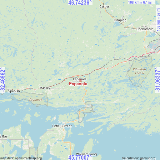
Espanola GPS coordinates[2]
46° 15' 30.132" North, 81° 45' 59.364" West
| Map corner | latitude | longitude |
|---|---|---|
| Upper-left | 46.74236°, | -82.46962° |
| Center: | 46.25837°, | -81.76649° |
| Lower-right: | 45.77007°, | -81.06337° |
| Map W x H: | 108.1×108.1 km | = 67.2×67.2mi |
| max Lat: | 73.03752° ⇑58% North |
| Espanola: | 46.25837° |
| min Lat: | ⇓42% South 42.05009° |
| min Long | Espanola | max Long |
| -139.43328° | -81.76649° | -52.70931° |
| W 38.4%⇐ | ⇒61.6% E |
Elevation
Elevation of Espanola is 204 m = 669 ft, and this is 50.4 m = 165 ft below average elevation for this country.
| Max E: |
1518 m = 4980 ft | 44.4% |
| Avg. | 254.4 m = 835 ft | |
| Espanola | 204 m = 669 ft | |
Min E: |
-2 m = -7 ft | 55.6% |
See also: Canada elevation on elevation.city.
Geographical zone
Espanola is located in North temperate zone (between Tropic of Cancer and the Arctic Circle). Distance of this North polar circle is 2257.7 km =1402.9 mi to North.| Distance of | km | miles | from Espanola |
|---|---|---|---|
| North Pole | 4863.6 | 3022.1 | to North |
| Arctic Circle | 2257.7 | 1402.9 | to North |
| Tropic Cancer | 2537.5 | 1576.7 | to South |
| Equator | 5143.4 | 3196 | to South |


Nearby cities:
15 places around Espanola: (largest is in red/bold)
• Azilda
60.5 km =37.6 mi,  57°
57°
• Cache Bay
137.5 km =85.4 mi,  84°
84°
• Capreol
81.7 km =50.8 mi,  52°
52°
• Dowling
49.4 km =30.7 mi,  41°
41°
• Elliot Lake
68 km =42.3 mi,  281°
281°
• Greater Sudbury
64.9 km =40.3 mi,  66°
66°
• Little Current
33.3 km =20.7 mi,  201°
201°
• Lively
51.2 km =31.8 mi, 67°
• North Bay
176.8 km =109.9 mi,  87°
87°
• Parry Sound
168.1 km =104.5 mi,  127°
127°
• Rayside-Balfour
57.9 km =36 mi, 47°
• Spanish
45.3 km =28.1 mi,  261°
261°
• Thessalon
138.4 km =86 mi,  269°
269°
• Tobermory
112.4 km =69.8 mi,  176°
176°
• Valley East
74.3 km =46.2 mi, 52°
Sources, notices
• [Note1] Compared only with cities in Canada existing in our database
• [Src1] Map data: © OpenStreetMap contributors (CC-BY-SA)
• [Src2] Other city data from geonames.org with taken over terms of usage.
• [Src3] Geographical zone / Annual Mean Temperature by Robert A. Rohde @ Wikipedia
