Tobermory geodata
Tobermory (Ontario) is a populated place; located in Canada in America/Toronto (GMT-4) time zone. With population of 1,427 people, there are 881 cities with bigger population in this country. Compared to other cities in Canada, 82.1% of cities are located further ↑North; 61.2% of cities are located further →East and 54% of cities have lower elevation than Tobermory. Note1
Administrative division(s):
- Level 1: Ontario
- Level 2: Bruce County
- Level 3: Northern Bruce Peninsula


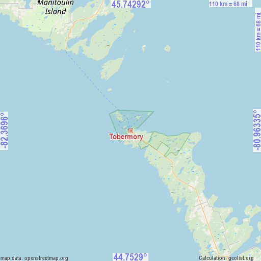
Tobermory GPS coordinates[2]
45° 15' 0.252" North, 81° 39' 59.292" West
| Map corner | latitude | longitude |
|---|---|---|
| Upper-left | 45.74292°, | -82.3696° |
| Center: | 45.25007°, | -81.66647° |
| Lower-right: | 44.7529°, | -80.96335° |
| Map W x H: | 110.1×110.1 km | = 68.4×68.4mi |
| max Lat: | 73.03752° ⇑82.1% North |
| Tobermory: | 45.25007° |
| min Lat: | ⇓17.9% South 42.05009° |
| min Long | Tobermory | max Long |
| -139.43328° | -81.66647° | -52.70931° |
| W 38.8%⇐ | ⇒61.2% E |
Elevation
Elevation of Tobermory is 192 m = 630 ft, and this is 62.4 m = 205 ft below average elevation for this country.
| Max E: |
1518 m = 4980 ft | 46% |
| Avg. | 254.4 m = 835 ft | |
| Tobermory | 192 m = 630 ft | |
Min E: |
-2 m = -7 ft | 54% |
See also: Canada elevation on elevation.city.
Geographical zone
Tobermory is located in North temperate zone (between Tropic of Cancer and the Arctic Circle). Distance of this North polar circle is 2369.8 km =1472.5 mi to North.| Distance of | km | miles | from Tobermory |
|---|---|---|---|
| North Pole | 4975.7 | 3091.8 | to North |
| Arctic Circle | 2369.8 | 1472.5 | to North |
| Tropic Cancer | 2425.4 | 1507.1 | to South |
| Equator | 5031.3 | 3126.3 | to South |


Nearby cities:
15 places around Tobermory: (largest is in red/bold)
• Collingwood
142.6 km =88.6 mi,  126°
126°
• Elliot Lake
146.6 km =91.1 mi,  329°
329°
• Espanola
112.4 km =69.8 mi,  356°
356°
• Hanover
132.2 km =82.1 mi,  157°
157°
• Kincardine
118.6 km =73.7 mi,  178°
178°
• Little Current
83.5 km =51.9 mi,  346°
346°
• Lively
137.5 km =85.4 mi,  16°
16°
• Markdale
131.2 km =81.5 mi,  142°
142°
• Meaford
109.6 km =68.1 mi, 130°
• Mildmay
140.3 km =87.2 mi, 161°
• Neustadt
140 km =87 mi, 157°
• Owen Sound
94.9 km =59 mi, 143°
• Paisley
109.4 km =68 mi, 163°
• Parry Sound
128 km =79.5 mi,  85°
85°
• Spanish
118.2 km =73.4 mi, 333°
Sources, notices
• [Note1] Compared only with cities in Canada existing in our database
• [Src1] Map data: © OpenStreetMap contributors (CC-BY-SA)
• [Src2] Other city data from geonames.org with taken over terms of usage.
• [Src3] Geographical zone / Annual Mean Temperature by Robert A. Rohde @ Wikipedia
