Azilda geodata
Azilda (Ontario) is a populated place; located in Canada in America/Toronto (GMT-4) time zone. With population of 4,663 people, there are 490 cities with bigger population in this country. Compared to other cities in Canada, 55.2% of cities are located further ↑North; 59.4% of cities are located further →East and 66.9% of cities have lower elevation than Azilda. Note1


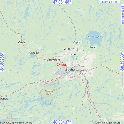
Azilda GPS coordinates[2]
46° 33' 0.288" North, 81° 5' 59.1" West
| Map corner | latitude | longitude |
|---|---|---|
| Upper-left | 47.03148°, | -81.80288° |
| Center: | 46.55008°, | -81.09975° |
| Lower-right: | 46.06437°, | -80.39663° |
| Map W x H: | 107.5×107.5 km | = 66.8×66.8mi |
| max Lat: | 73.03752° ⇑55.2% North |
| Azilda: | 46.55008° |
| min Lat: | ⇓44.8% South 42.05009° |
| min Long | Azilda | max Long |
| -139.43328° | -81.09975° | -52.70931° |
| W 40.6%⇐ | ⇒59.4% E |
Elevation
Elevation of Azilda is 270 m = 886 ft, and this is 15.6 m = 51 ft above average elevation for this country.
| Max E: |
1518 m = 4980 ft | 33.1% |
| Azilda | 270 m 886 ft | |
| Avg. | 254.4 m = 835 ft | |
Min E: |
-2 m = -7 ft | 66.9% |
See also: Canada elevation on elevation.city.
Geographical zone
Azilda is located in North temperate zone (between Tropic of Cancer and the Arctic Circle). Distance of this North polar circle is 2225.3 km =1382.7 mi to North.| Distance of | km | miles | from Azilda |
|---|---|---|---|
| North Pole | 4831.2 | 3002 | to North |
| Arctic Circle | 2225.3 | 1382.7 | to North |
| Tropic Cancer | 2570 | 1596.9 | to South |
| Equator | 5175.9 | 3216.2 | to South |


Nearby cities:
15 places around Azilda: (largest is in red/bold)
• Cache Bay
87.9 km =54.6 mi,  103°
103°
• Capreol
22.1 km =13.7 mi,  38°
38°
• Dowling
18.9 km =11.7 mi,  283°
283°
• Elliot Lake
118.9 km =73.9 mi,  261°
261°
• Espanola
60.5 km =37.6 mi,  237°
237°
• Greater Sudbury
10.7 km =6.6 mi,  128°
128°
• Little Current
89.7 km =55.7 mi,  224°
224°
• Lively
13.5 km =8.4 mi,  196°
196°
• North Bay
127.8 km =79.4 mi, 101°
• Powassan
146.2 km =90.8 mi,  113°
113°
• Rayside-Balfour
10.5 km =6.5 mi,  308°
308°
• Spanish
103.5 km =64.3 mi,  247°
247°
• Temiskaming Shores
148.4 km =92.2 mi,  45°
45°
• Tobermory
151.1 km =93.9 mi, 196°
• Valley East
15.1 km =9.4 mi,  30°
30°
Sources, notices
• [Note1] Compared only with cities in Canada existing in our database
• [Src1] Map data: © OpenStreetMap contributors (CC-BY-SA)
• [Src2] Other city data from geonames.org with taken over terms of usage.
• [Src3] Geographical zone / Annual Mean Temperature by Robert A. Rohde @ Wikipedia
