Dowling geodata
Dowling (Ontario) is a populated place; located in Canada in America/Toronto (GMT-4) time zone. With population of 1,466 people, there are 872 cities with bigger population in this country. Compared to other cities in Canada, 54.9% of cities are located further ↑North; 60.4% of cities are located further →East and 66.9% of cities have lower elevation than Dowling. Note1


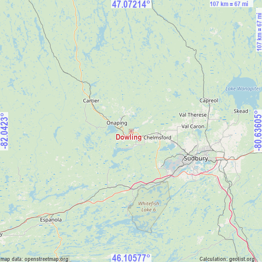
Dowling GPS coordinates[2]
46° 35' 27.996" North, 81° 20' 21.012" West
| Map corner | latitude | longitude |
|---|---|---|
| Upper-left | 47.07214°, | -82.0423° |
| Center: | 46.59111°, | -81.33917° |
| Lower-right: | 46.10577°, | -80.63605° |
| Map W x H: | 107.5×107.4 km | = 66.8×66.7mi |
| max Lat: | 73.03752° ⇑54.9% North |
| Dowling: | 46.59111° |
| min Lat: | ⇓45.1% South 42.05009° |
| min Long | Dowling | max Long |
| -139.43328° | -81.33917° | -52.70931° |
| W 39.6%⇐ | ⇒60.4% E |
Elevation
Elevation of Dowling is 270 m = 886 ft, and this is 15.6 m = 51 ft above average elevation for this country.
| Max E: |
1518 m = 4980 ft | 33.1% |
| Dowling | 270 m 886 ft | |
| Avg. | 254.4 m = 835 ft | |
Min E: |
-2 m = -7 ft | 66.9% |
See also: Canada elevation on elevation.city.
Geographical zone
Dowling is located in North temperate zone (between Tropic of Cancer and the Arctic Circle). Distance of this North polar circle is 2220.7 km =1379.9 mi to North.| Distance of | km | miles | from Dowling |
|---|---|---|---|
| North Pole | 4826.6 | 2999.1 | to North |
| Arctic Circle | 2220.7 | 1379.9 | to North |
| Tropic Cancer | 2574.5 | 1599.7 | to South |
| Equator | 5180.4 | 3219 | to South |


Nearby cities:
15 places around Dowling: (largest is in red/bold)
• Azilda
18.9 km =11.7 mi,  103°
103°
• Cache Bay
106.8 km =66.4 mi, 103°
• Capreol
34.4 km =21.4 mi,  68°
68°
• Elliot Lake
101.7 km =63.2 mi,  256°
256°
• Espanola
49.4 km =30.7 mi,  221°
221°
• Greater Sudbury
29 km =18 mi,  112°
112°
• Little Current
81.6 km =50.7 mi,  213°
213°
• Lively
22.8 km =14.2 mi,  140°
140°
• North Bay
146.7 km =91.2 mi, 102°
• Powassan
164.9 km =102.5 mi, 112°
• Rayside-Balfour
10.2 km =6.3 mi,  78°
78°
• Spanish
88.9 km =55.2 mi,  240°
240°
• Temiskaming Shores
158.8 km =98.7 mi,  50°
50°
• Tobermory
151.2 km =94 mi,  189°
189°
• Valley East
27.2 km =16.9 mi, 71°
Sources, notices
• [Note1] Compared only with cities in Canada existing in our database
• [Src1] Map data: © OpenStreetMap contributors (CC-BY-SA)
• [Src2] Other city data from geonames.org with taken over terms of usage.
• [Src3] Geographical zone / Annual Mean Temperature by Robert A. Rohde @ Wikipedia
