Spanish geodata
Spanish (Ontario) is a populated place; located in Canada in America/Toronto (GMT-4) time zone. With population of 639 people, there are 1137 cities with bigger population in this country. Compared to other cities in Canada, 59.4% of cities are located further ↑North; 62.4% of cities are located further →East and 56.2% of cities have lower elevation than Spanish. Note1


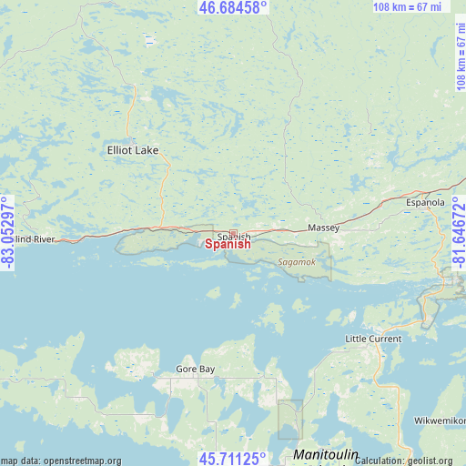
Spanish GPS coordinates[2]
46° 12' 0.252" North, 82° 20' 59.424" West
| Map corner | latitude | longitude |
|---|---|---|
| Upper-left | 46.68458°, | -83.05297° |
| Center: | 46.20007°, | -82.34984° |
| Lower-right: | 45.71125°, | -81.64672° |
| Map W x H: | 108.2×108.2 km | = 67.2×67.2mi |
| max Lat: | 73.03752° ⇑59.4% North |
| Spanish: | 46.20007° |
| min Lat: | ⇓40.6% South 42.05009° |
| min Long | Spanish | max Long |
| -139.43328° | -82.34984° | -52.70931° |
| W 37.6%⇐ | ⇒62.4% E |
Elevation
Elevation of Spanish is 208 m = 682 ft, and this is 46.4 m = 152 ft below average elevation for this country.
| Max E: |
1518 m = 4980 ft | 43.8% |
| Avg. | 254.4 m = 835 ft | |
| Spanish | 208 m = 682 ft | |
Min E: |
-2 m = -7 ft | 56.2% |
See also: Canada elevation on elevation.city.
Geographical zone
Spanish is located in North temperate zone (between Tropic of Cancer and the Arctic Circle). Distance of this North polar circle is 2264.2 km =1406.9 mi to North.| Distance of | km | miles | from Spanish |
|---|---|---|---|
| North Pole | 4870.1 | 3026.1 | to North |
| Arctic Circle | 2264.2 | 1406.9 | to North |
| Tropic Cancer | 2531 | 1572.7 | to South |
| Equator | 5137 | 3192 | to South |


Nearby cities:
15 places around Spanish: (largest is in red/bold)
• Azilda
103.5 km =64.3 mi,  67°
67°
• Cache Bay
182.8 km =113.6 mi,  84°
84°
• Capreol
123.1 km =76.5 mi,  62°
62°
• Dowling
88.9 km =55.2 mi, 60°
• Elliot Lake
29.8 km =18.5 mi,  313°
313°
• Espanola
45.3 km =28.1 mi, 81°
• Greater Sudbury
109.2 km =67.9 mi, 72°
• Little Current
41 km =25.5 mi,  126°
126°
• Lively
95.7 km =59.5 mi, 74°
• Parry Sound
203 km =126.1 mi,  117°
117°
• Rayside-Balfour
98.7 km =61.3 mi, 62°
• Sault Ste. Marie
156.2 km =97.1 mi,  283°
283°
• Thessalon
93.8 km =58.3 mi,  273°
273°
• Tobermory
118.2 km =73.4 mi,  153°
153°
• Valley East
115.8 km =72 mi, 63°
Sources, notices
• [Note1] Compared only with cities in Canada existing in our database
• [Src1] Map data: © OpenStreetMap contributors (CC-BY-SA)
• [Src2] Other city data from geonames.org with taken over terms of usage.
• [Src3] Geographical zone / Annual Mean Temperature by Robert A. Rohde @ Wikipedia
