Barrière geodata
Barrière (British Columbia) is a populated place; located in Canada in America/Vancouver (GMT-7) time zone. With population of 1,283 people, there are 927 cities with bigger population in this country. Compared to other cities in Canada, 83.1% of cities are located further ↓South; 89.2% of cities are located further →East and 78.1% of cities have lower elevation than Barrière. Note1
Administrative division(s):
- Level 1: British Columbia
- Level 2: Thompson-Nicola Regional District
- Level 3: Barriere


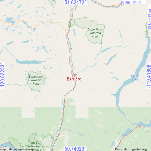
Barrière GPS coordinates[2]
51° 10' 59.088" North, 120° 7' 9.12" West
| Map corner | latitude | longitude |
|---|---|---|
| Upper-left | 51.62172°, | -120.82233° |
| Center: | 51.18308°, | -120.1192° |
| Lower-right: | 50.74023°, | -119.41608° |
| Map W x H: | 98×98 km | = 60.9×60.9mi |
| max Lat: | 73.03752° ⇑16.9% North |
| Barrière: | 51.18308° |
| min Lat: | ⇓83.1% South 42.05009° |
| min Long | Barrière | max Long |
| -139.43328° | -120.1192° | -52.70931° |
| W 10.8%⇐ | ⇒89.2% E |
Elevation
Elevation of Barrière is 399 m = 1309 ft, and this is 144.6 m = 474 ft above average elevation for this country.
| Max E: |
1518 m = 4980 ft | 21.9% |
| Barrière | 399 m 1309 ft | |
| Avg. | 254.4 m = 835 ft | |
Min E: |
-2 m = -7 ft | 78.1% |
See also: Canada elevation on elevation.city.
Geographical zone
Barrière is located in North temperate zone (between Tropic of Cancer and the Arctic Circle). Distance of this North polar circle is 1710.1 km =1062.6 mi to North.| Distance of | km | miles | from Barrière |
|---|---|---|---|
| North Pole | 4316 | 2681.8 | to North |
| Arctic Circle | 1710.1 | 1062.6 | to North |
| Tropic Cancer | 3085.1 | 1917 | to South |
| Equator | 5691 | 3536.2 | to South |


Nearby cities:
15 places around Barrière: (largest is in red/bold)
• Armstrong
103.9 km =64.6 mi,  141°
141°
• Ashcroft
96.1 km =59.7 mi,  237°
237°
• Cache Creek
94 km =58.4 mi, 243°
• Chase
50.8 km =31.6 mi, 143°
• Clinton
102.9 km =63.9 mi,  263°
263°
• Enderby
97.8 km =60.8 mi, 136°
• Falkland
85.8 km =53.3 mi,  152°
152°
• Kamloops
59.1 km =36.7 mi,  193°
193°
• Logan Lake
89.9 km =55.9 mi,  212°
212°
• Ranchero
87.1 km =54.1 mi,  132°
132°
• Salmon Arm
78.5 km =48.8 mi, 133°
• Scotch Creek
56.3 km =35 mi,  124°
124°
• Sicamous
88.3 km =54.9 mi, 116°
• Sunnybrae
75.4 km =46.9 mi, 127°
• White Lake
66.1 km =41.1 mi, 120°
Sources, notices
• [Note1] Compared only with cities in Canada existing in our database
• [Src1] Map data: © OpenStreetMap contributors (CC-BY-SA)
• [Src2] Other city data from geonames.org with taken over terms of usage.
• [Src3] Geographical zone / Annual Mean Temperature by Robert A. Rohde @ Wikipedia
