Summerside geodata
Summerside (Prince Edward Island) is a populated place; located in Canada in America/Halifax (GMT-3) time zone. With population of 14,808 people, there are 247 cities with bigger population in this country. Compared to other cities in Canada, 56.2% of cities are located further ↑North; 94.2% of cities are located further ←West and 89.1% of cities have higher elevation than Summerside. Note1


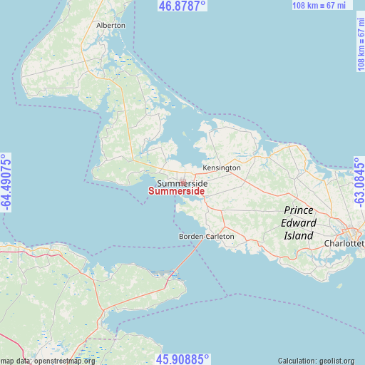
Summerside GPS coordinates[2]
46° 23' 45.348" North, 63° 47' 15.432" West
| Map corner | latitude | longitude |
|---|---|---|
| Upper-left | 46.8787°, | -64.49075° |
| Center: | 46.39593°, | -63.78762° |
| Lower-right: | 45.90885°, | -63.0845° |
| Map W x H: | 107.8×107.8 km | = 67×67mi |
| max Lat: | 73.03752° ⇑56.2% North |
| Summerside: | 46.39593° |
| min Lat: | ⇓43.8% South 42.05009° |
| min Long | Summerside | max Long |
| -139.43328° | -63.78762° | -52.70931° |
| W 94.2%⇐ | ⇒5.8% E |
Elevation
Elevation of Summerside is 16 m = 52 ft, and this is 238.4 m = 782 ft below average elevation for this country.
| Max E: |
1518 m = 4980 ft | 89.1% |
| Avg. | 254.4 m = 835 ft | |
| Summerside | 16 m = 52 ft | |
Min E: |
-2 m = -7 ft | 10.9% |
See also: Canada elevation on elevation.city.
Geographical zone
Summerside is located in North temperate zone (between Tropic of Cancer and the Arctic Circle). Distance of this North polar circle is 2242.4 km =1393.4 mi to North.| Distance of | km | miles | from Summerside |
|---|---|---|---|
| North Pole | 4848.3 | 3012.6 | to North |
| Arctic Circle | 2242.4 | 1393.4 | to North |
| Tropic Cancer | 2552.8 | 1586.2 | to South |
| Equator | 5158.7 | 3205.5 | to South |


Nearby cities:
15 places around Summerside: (largest is in red/bold)
• Alberton
51.4 km =31.9 mi,  335°
335°
• Amherst
70.1 km =43.6 mi,  206°
206°
• Bouctouche
73.4 km =45.6 mi,  276°
276°
• Charlottetown
53.1 km =33 mi,  109°
109°
• Cornwall
47.6 km =29.6 mi, 113°
• Grande-Digue
60.6 km =37.7 mi,  259°
259°
• Haute-Aboujagane
54.5 km =33.9 mi,  239°
239°
• Kensington
11.4 km =7.1 mi,  68°
68°
• Oxford
73.9 km =45.9 mi,  184°
184°
• Point de Bute
65.2 km =40.5 mi, 212°
• Sackville
70.2 km =43.6 mi,  220°
220°
• Saint-Antoine
73.9 km =45.9 mi,  267°
267°
• Shediac
61.1 km =38 mi,  251°
251°
• Shediac Bridge-Shediac River
64 km =39.8 mi, 257°
• Shediac Cape
62.4 km =38.8 mi, 253°
Sources, notices
• [Note1] Compared only with cities in Canada existing in our database
• [Src1] Map data: © OpenStreetMap contributors (CC-BY-SA)
• [Src2] Other city data from geonames.org with taken over terms of usage.
• [Src3] Geographical zone / Annual Mean Temperature by Robert A. Rohde @ Wikipedia
