Libenge geodata
Libenge (Sud-Ubangi) is a populated place; located in Democratic Republic of the Congo in Africa/Kinshasa (GMT+1) time zone. With population of 27,053 people, there are 61 cities with bigger population in this country. Compared to other cities in Democratic Republic of the Congo, 95.7% of cities are located further ↓South; 75.7% of cities are located further →East and 78.6% of cities have higher elevation than Libenge. Note1


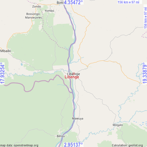
Libenge GPS coordinates[2]
3° 39' 11.952" North, 18° 38' 8.376" East
| Map corner | latitude | longitude |
|---|---|---|
| Upper-left | 4.35472°, | 17.93254° |
| Center: | 3.65332°, | 18.63566° |
| Lower-right: | 2.95137°, | 19.33879° |
| Map W x H: | 156×156 km | = 96.9×96.9mi |
| max Lat: | 4.279° ⇑4.3% North |
| Libenge: | 3.65332° |
| min Lat: | ⇓95.7% South -11.76097° |
| min Long | Libenge | max Long |
| 12.37148° | 18.63566° | 30.25224° |
| W 24.3%⇐ | ⇒75.7% E |
Elevation
Elevation of Libenge is 358 m = 1175 ft, and this is 298 m = 978 ft below average elevation for this country.
| Max E: |
1996 m = 6549 ft | 78.6% |
| Avg. | 656 m = 2152 ft | |
| Libenge | 358 m = 1175 ft | |
Min E: |
11 m = 36 ft | 21.4% |
See also: Democratic Republic of the Congo elevation on elevation.city.
Geographical zone
Libenge is located in North Torrid zone (between Equator and Tropic of Cancer). Distance of Equator is 406.2 km =252.4 mi to South.| Distance of | km | miles | from Libenge |
|---|---|---|---|
| North Pole | 9600.9 | 5965.7 | to North |
| Arctic Circle | 6995 | 4346.5 | to North |
| Tropic Cancer | 2199.7 | 1366.8 | to North |
| Equator | 406.2 | 252.4 | to South |


Nearby cities:
7 places around Libenge: (largest is in red/bold)
• Bongandanga
360.9 km =224.3 mi,  131°
131°
• Bosobolo
150.7 km =93.6 mi,  66°
66°
• Businga
252.2 km =156.7 mi,  97°
97°
• Gbadolite
271.6 km =168.8 mi,  75°
75°
• Gemena
133.6 km =83 mi,  109°
109°
• Lisala
360.9 km =224.3 mi,  117°
117°
• Mbandaka
403 km =250.4 mi,  185°
185°
Sources, notices
• [Note1] Compared only with cities in Democratic Republic of the Congo existing in our database
• [Src1] Map data: © OpenStreetMap contributors (CC-BY-SA)
• [Src2] Other city data from geonames.org with taken over terms of usage.
• [Src3] Geographical zone / Annual Mean Temperature by Robert A. Rohde @ Wikipedia
