Lisala geodata
Lisala (Équateur) is a populated place; located in Democratic Republic of the Congo in Africa/Kinshasa (GMT+1) time zone. With population of 70,087 people, there are 30 cities with bigger population in this country. Compared to other cities in Democratic Republic of the Congo, 84.3% of cities are located further ↓South; 58.6% of cities are located further →East and 62.9% of cities have higher elevation than Lisala. Note1


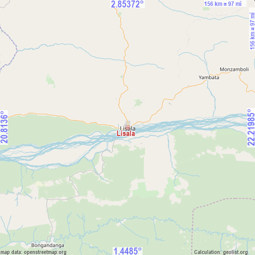
Lisala GPS coordinates[2]
2° 9' 4.572" North, 21° 31' 0.192" East
| Map corner | latitude | longitude |
|---|---|---|
| Upper-left | 2.85372°, | 20.8136° |
| Center: | 2.15127°, | 21.51672° |
| Lower-right: | 1.4485°, | 22.21985° |
| Map W x H: | 156.2×156.3 km | = 97.1×97.1mi |
| max Lat: | 4.279° ⇑15.7% North |
| Lisala: | 2.15127° |
| min Lat: | ⇓84.3% South -11.76097° |
| min Long | Lisala | max Long |
| 12.37148° | 21.51672° | 30.25224° |
| W 41.4%⇐ | ⇒58.6% E |
Elevation
Elevation of Lisala is 418 m = 1371 ft, and this is 238 m = 781 ft below average elevation for this country.
| Max E: |
1996 m = 6549 ft | 62.9% |
| Avg. | 656 m = 2152 ft | |
| Lisala | 418 m = 1371 ft | |
Min E: |
11 m = 36 ft | 37.1% |
See also: Lisala elevation on elevation.city.
Geographical zone
Lisala is located in North Torrid zone (between Equator and Tropic of Cancer). Distance of Equator is 239.2 km =148.6 mi to South.| Distance of | km | miles | from Lisala |
|---|---|---|---|
| North Pole | 9767.9 | 6069.5 | to North |
| Arctic Circle | 7162 | 4450.3 | to North |
| Tropic Cancer | 2366.7 | 1470.6 | to North |
| Equator | 239.2 | 148.6 | to South |


Nearby cities:
14 places around Lisala: (largest is in red/bold)
• Aketi
260.1 km =161.6 mi,  75°
75°
• Basoko
254.4 km =158.1 mi,  113°
113°
• Boende
279.6 km =173.7 mi,  194°
194°
• Bondo
303.7 km =188.7 mi,  52°
52°
• Bongandanga
87 km =54.1 mi,  214°
214°
• Bosobolo
290.3 km =180.4 mi,  321°
321°
• Bumba
105.8 km =65.7 mi,  87°
87°
• Businga
149.5 km =92.9 mi,  332°
332°
• Buta
363.9 km =226.1 mi, 78°
• Gbadolite
243.4 km =151.2 mi,  346°
346°
• Gemena
229.4 km =142.5 mi,  302°
302°
• Libenge
360.9 km =224.3 mi, 297°
• Mbandaka
430.9 km =267.7 mi,  237°
237°
• Yangambi
359.5 km =223.4 mi,  115°
115°
Sources, notices
• [Note1] Compared only with cities in Democratic Republic of the Congo existing in our database
• [Src1] Map data: © OpenStreetMap contributors (CC-BY-SA)
• [Src2] Other city data from geonames.org with taken over terms of usage.
• [Src3] Geographical zone / Annual Mean Temperature by Robert A. Rohde @ Wikipedia
