Businga geodata
Businga (Nord-Ubangi) is a populated place; located in Democratic Republic of the Congo in Africa/Kinshasa (GMT+1) time zone. With population of 28,919 people, there are 58 cities with bigger population in this country. Compared to other cities in Democratic Republic of the Congo, 94.3% of cities are located further ↓South; 64.3% of cities are located further →East and 77.1% of cities have higher elevation than Businga. Note1


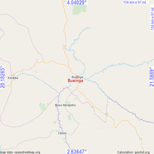
Businga GPS coordinates[2]
3° 20' 19.068" North, 20° 53' 8.772" East
| Map corner | latitude | longitude |
|---|---|---|
| Upper-left | 4.04029°, | 20.18265° |
| Center: | 3.33863°, | 20.88577° |
| Lower-right: | 2.63647°, | 21.5889° |
| Map W x H: | 156.1×156.1 km | = 97×97mi |
| max Lat: | 4.279° ⇑5.7% North |
| Businga: | 3.33863° |
| min Lat: | ⇓94.3% South -11.76097° |
| min Long | Businga | max Long |
| 12.37148° | 20.88577° | 30.25224° |
| W 35.7%⇐ | ⇒64.3% E |
Elevation
Elevation of Businga is 362 m = 1188 ft, and this is 294 m = 965 ft below average elevation for this country.
| Max E: |
1996 m = 6549 ft | 77.1% |
| Avg. | 656 m = 2152 ft | |
| Businga | 362 m = 1188 ft | |
Min E: |
11 m = 36 ft | 22.9% |
See also: Democratic Republic of the Congo elevation on elevation.city.
Geographical zone
Businga is located in North Torrid zone (between Equator and Tropic of Cancer). Distance of Equator is 371.2 km =230.7 mi to South.| Distance of | km | miles | from Businga |
|---|---|---|---|
| North Pole | 9635.8 | 5987.4 | to North |
| Arctic Circle | 7030 | 4368.2 | to North |
| Tropic Cancer | 2234.7 | 1388.6 | to North |
| Equator | 371.2 | 230.7 | to South |


Nearby cities:
12 places around Businga: (largest is in red/bold)
• Aketi
328.6 km =204.2 mi,  101°
101°
• Basoko
382.7 km =237.8 mi,  127°
127°
• Boende
402.5 km =250.1 mi,  180°
180°
• Bondo
315.3 km =195.9 mi,  80°
80°
• Bongandanga
204.7 km =127.2 mi,  174°
174°
• Bosobolo
146 km =90.7 mi,  310°
310°
• Bumba
217.4 km =135.1 mi, 126°
• Buta
431.2 km =267.9 mi, 98°
• Gbadolite
105.4 km =65.5 mi,  7°
7°
• Gemena
123.9 km =77 mi,  265°
265°
• Libenge
252.2 km =156.7 mi,  277°
277°
• Lisala
149.5 km =92.9 mi,  152°
152°
Sources, notices
• [Note1] Compared only with cities in Democratic Republic of the Congo existing in our database
• [Src1] Map data: © OpenStreetMap contributors (CC-BY-SA)
• [Src2] Other city data from geonames.org with taken over terms of usage.
• [Src3] Geographical zone / Annual Mean Temperature by Robert A. Rohde @ Wikipedia
