Bongandanga geodata
Bongandanga (Sud-Ubangi) is a populated place; located in Democratic Republic of the Congo in Africa/Kinshasa (GMT+1) time zone. With population of 4,105 people, there are 70 cities with bigger population in this country. Compared to other cities in Democratic Republic of the Congo, 80% of cities are located further ↓South; 61.4% of cities are located further →East and 71.4% of cities have higher elevation than Bongandanga. Note1


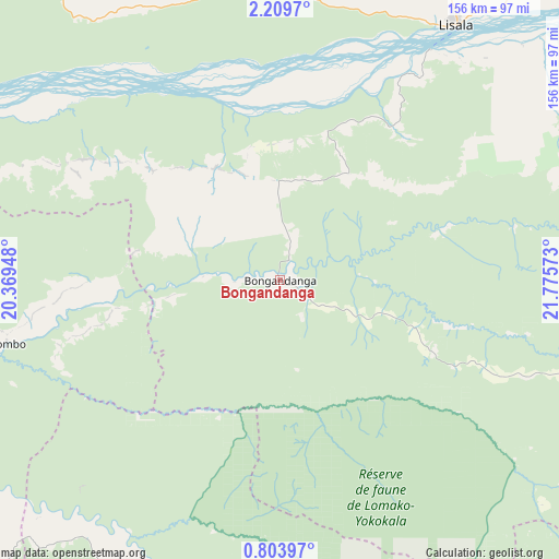
Bongandanga GPS coordinates[2]
1° 30' 25.02" North, 21° 4' 21.36" East
| Map corner | latitude | longitude |
|---|---|---|
| Upper-left | 2.2097°, | 20.36948° |
| Center: | 1.50695°, | 21.0726° |
| Lower-right: | 0.80397°, | 21.77573° |
| Map W x H: | 156.3×156.3 km | = 97.1×97.1mi |
| max Lat: | 4.279° ⇑20% North |
| Bongandanga: | 1.50695° |
| min Lat: | ⇓80% South -11.76097° |
| min Long | Bongandanga | max Long |
| 12.37148° | 21.0726° | 30.25224° |
| W 38.6%⇐ | ⇒61.4% E |
Elevation
Elevation of Bongandanga is 389 m = 1276 ft, and this is 267 m = 876 ft below average elevation for this country.
| Max E: |
1996 m = 6549 ft | 71.4% |
| Avg. | 656 m = 2152 ft | |
| Bongandanga | 389 m = 1276 ft | |
Min E: |
11 m = 36 ft | 28.6% |
See also: Democratic Republic of the Congo elevation on elevation.city.
Geographical zone
Bongandanga is located in North Torrid zone (between Equator and Tropic of Cancer). Distance of Equator is 167.6 km =104.1 mi to South.| Distance of | km | miles | from Bongandanga |
|---|---|---|---|
| North Pole | 9839.5 | 6114 | to North |
| Arctic Circle | 7233.6 | 4494.7 | to North |
| Tropic Cancer | 2438.4 | 1515.2 | to North |
| Equator | 167.6 | 104.1 | to South |


Nearby cities:
14 places around Bongandanga: (largest is in red/bold)
• Aketi
330.9 km =205.6 mi,  65°
65°
• Basoko
284.3 km =176.7 mi,  96°
96°
• Boende
200 km =124.3 mi,  186°
186°
• Bondo
387.5 km =240.8 mi,  48°
48°
• Bosobolo
326.2 km =202.7 mi,  336°
336°
• Bumba
172.6 km =107.2 mi,  63°
63°
• Businga
204.7 km =127.2 mi,  354°
354°
• Buta
430.5 km =267.5 mi, 70°
• Gbadolite
308.3 km =191.6 mi,  358°
358°
• Gemena
242.3 km =150.6 mi,  323°
323°
• Libenge
360.9 km =224.3 mi,  311°
311°
• Lisala
87 km =54.1 mi,  34°
34°
• Mbandaka
352.2 km =218.8 mi,  242°
242°
• Yangambi
383.2 km =238.1 mi, 102°
Sources, notices
• [Note1] Compared only with cities in Democratic Republic of the Congo existing in our database
• [Src1] Map data: © OpenStreetMap contributors (CC-BY-SA)
• [Src2] Other city data from geonames.org with taken over terms of usage.
• [Src3] Geographical zone / Annual Mean Temperature by Robert A. Rohde @ Wikipedia
