Bosobolo geodata
Bosobolo (Nord-Ubangi) is a populated place; located in Democratic Republic of the Congo in Africa/Kinshasa (GMT+1) time zone. With population of 14,553 people, there are 69 cities with bigger population in this country. Compared to other cities in Democratic Republic of the Congo, 98.6% of cities are located further ↓South; 70% of cities are located further →East and 57.1% of cities have higher elevation than Bosobolo. Note1


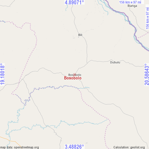
Bosobolo GPS coordinates[2]
4° 11' 23.28" North, 19° 52' 59.88" East
| Map corner | latitude | longitude |
|---|---|---|
| Upper-left | 4.89071°, | 19.18018° |
| Center: | 4.1898°, | 19.8833° |
| Lower-right: | 3.48826°, | 20.58643° |
| Map W x H: | 155.9×155.9 km | = 96.9×96.9mi |
| max Lat: | 4.279° ⇑1.4% North |
| Bosobolo: | 4.1898° |
| min Lat: | ⇓98.6% South -11.76097° |
| min Long | Bosobolo | max Long |
| 12.37148° | 19.8833° | 30.25224° |
| W 30%⇐ | ⇒70% E |
Elevation
Elevation of Bosobolo is 442 m = 1450 ft, and this is 214 m = 702 ft below average elevation for this country.
| Max E: |
1996 m = 6549 ft | 57.1% |
| Avg. | 656 m = 2152 ft | |
| Bosobolo | 442 m = 1450 ft | |
Min E: |
11 m = 36 ft | 42.9% |
See also: Democratic Republic of the Congo elevation on elevation.city.
Geographical zone
Bosobolo is located in North Torrid zone (between Equator and Tropic of Cancer). Distance of Equator is 465.9 km =289.5 mi to South.| Distance of | km | miles | from Bosobolo |
|---|---|---|---|
| North Pole | 9541.2 | 5928.6 | to North |
| Arctic Circle | 6935.3 | 4309.4 | to North |
| Tropic Cancer | 2140.1 | 1329.8 | to North |
| Equator | 465.9 | 289.5 | to South |


Nearby cities:
8 places around Bosobolo: (largest is in red/bold)
• Bondo
423.9 km =263.4 mi,  95°
95°
• Bongandanga
326.2 km =202.7 mi,  156°
156°
• Bumba
363.2 km =225.7 mi,  127°
127°
• Businga
146 km =90.7 mi, 130°
• Gbadolite
124.5 km =77.4 mi,  85°
85°
• Gemena
104.5 km =64.9 mi,  186°
186°
• Libenge
150.7 km =93.6 mi,  246°
246°
• Lisala
290.3 km =180.4 mi,  141°
141°
Sources, notices
• [Note1] Compared only with cities in Democratic Republic of the Congo existing in our database
• [Src1] Map data: © OpenStreetMap contributors (CC-BY-SA)
• [Src2] Other city data from geonames.org with taken over terms of usage.
• [Src3] Geographical zone / Annual Mean Temperature by Robert A. Rohde @ Wikipedia
