Bauen geodata
Bauen (Uri) is a seat of a third-order administrative division; located in Switzerland in Europe/Zurich (GMT+2) time zone. With population of 206 people, there are 1818 cities with bigger population in this country. Compared to other cities in Switzerland, 67.6% of cities are located further ↑North; 63.8% of cities are located further ←West and 55.1% of cities have higher elevation than Bauen. Note1


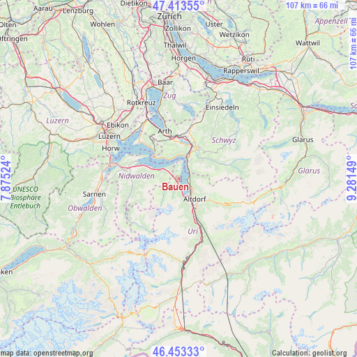
Bauen GPS coordinates[2]
46° 56' 8.124" North, 8° 34' 42.096" East
| Map corner | latitude | longitude |
|---|---|---|
| Upper-left | 47.41355°, | 7.87524° |
| Center: | 46.93559°, | 8.57836° |
| Lower-right: | 46.45333°, | 9.28149° |
| Map W x H: | 106.8×106.8 km | = 66.4×66.4mi |
| max Lat: | 47.76737° ⇑67.6% North |
| Bauen: | 46.93559° |
| min Lat: | ⇓32.4% South 45.83203° |
| min Long | Bauen | max Long |
| 5.97153° | 8.57836° | 10.44624° |
| W 63.8%⇐ | ⇒36.2% E |
Elevation
Elevation of Bauen is 467 m = 1532 ft, and this is 91.2 m = 299 ft below average elevation for this country.
| Max E: |
1845 m = 6053 ft | 55.1% |
| Avg. | 558.2 m = 1831 ft | |
| Bauen | 467 m = 1532 ft | |
Min E: |
197 m = 646 ft | 44.9% |
See also: Switzerland elevation on elevation.city.
Geographical zone
Bauen is located in North temperate zone (between Tropic of Cancer and the Arctic Circle). Distance of this North polar circle is 2182.4 km =1356.1 mi to North.| Distance of | km | miles | from Bauen |
|---|---|---|---|
| North Pole | 4788.3 | 2975.3 | to North |
| Arctic Circle | 2182.4 | 1356.1 | to North |
| Tropic Cancer | 2612.8 | 1623.5 | to South |
| Equator | 5218.7 | 3242.7 | to South |


Nearby cities:
15 places around Bauen: (largest is in red/bold)
• Altdorf
7.9 km =4.9 mi,  140°
140°
• Attinghausen
9 km =5.6 mi,  154°
154°
• Beckenried
8.5 km =5.3 mi,  293°
293°
• Bürglen
9.4 km =5.8 mi, 135°
• Emmetten
5.4 km =3.4 mi,  295°
295°
• Flüelen
4.9 km =3 mi,  134°
134°
• Gersau
7.7 km =4.8 mi,  328°
328°
• Ibach
9.8 km =6.1 mi,  31°
31°
• Ingenbohl
7.6 km =4.7 mi,  21°
21°
• Isenthal
3 km =1.9 mi,  205°
205°
• Lauerz
10.9 km =6.8 mi,  2°
2°
• Morschach
6.1 km =3.8 mi, 30°
• Schattdorf
9.7 km =6 mi, 143°
• Seedorf
6.6 km =4.1 mi, 154°
• Seelisberg
4.2 km =2.6 mi,  8°
8°
Sources, notices
• [Note1] Compared only with cities in Switzerland existing in our database
• [Src1] Map data: © OpenStreetMap contributors (CC-BY-SA)
• [Src2] Other city data from geonames.org with taken over terms of usage.
• [Src3] Geographical zone / Annual Mean Temperature by Robert A. Rohde @ Wikipedia
