Illgau geodata
Illgau (Schwyz) is a populated place; located in Switzerland in Europe/Zurich (GMT+2) time zone. With population of 752 people, there are 1534 cities with bigger population in this country. Compared to other cities in Switzerland, 64.9% of cities are located further ↑North; 76.6% of cities are located further ←West and 90.1% of cities have lower elevation than Illgau. Note1


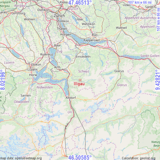
Illgau GPS coordinates[2]
46° 59' 15.504" North, 8° 43' 30.324" East
| Map corner | latitude | longitude |
|---|---|---|
| Upper-left | 47.46513°, | 8.02196° |
| Center: | 46.98764°, | 8.72509° |
| Lower-right: | 46.50585°, | 9.42821° |
| Map W x H: | 106.7×106.7 km | = 66.3×66.3mi |
| max Lat: | 47.76737° ⇑64.9% North |
| Illgau: | 46.98764° |
| min Lat: | ⇓35.1% South 45.83203° |
| min Long | Illgau | max Long |
| 5.97153° | 8.72509° | 10.44624° |
| W 76.6%⇐ | ⇒23.4% E |
Elevation
Elevation of Illgau is 820 m = 2690 ft, and this is 261.8 m = 859 ft above average elevation for this country.
| Max E: |
1845 m = 6053 ft | 9.9% |
| Illgau | 820 m 2690 ft | |
| Avg. | 558.2 m = 1831 ft | |
Min E: |
197 m = 646 ft | 90.1% |
See also: Switzerland elevation on elevation.city.
Geographical zone
Illgau is located in North temperate zone (between Tropic of Cancer and the Arctic Circle). Distance of this North polar circle is 2176.6 km =1352.5 mi to North.| Distance of | km | miles | from Illgau |
|---|---|---|---|
| North Pole | 4782.5 | 2971.7 | to North |
| Arctic Circle | 2176.6 | 1352.5 | to North |
| Tropic Cancer | 2618.6 | 1627.1 | to South |
| Equator | 5224.5 | 3246.4 | to South |


Nearby cities:
15 places around Illgau: (largest is in red/bold)
• Alpthal
9.1 km =5.7 mi,  355°
355°
• Bauen
12.5 km =7.8 mi,  242°
242°
• Flüelen
12 km =7.5 mi,  219°
219°
• Ibach
6.6 km =4.1 mi,  293°
293°
• Ingenbohl
8.4 km =5.2 mi,  278°
278°
• Lauerz
11.9 km =7.4 mi,  295°
295°
• Morschach
8.1 km =5 mi,  266°
266°
• Muotathal
3.3 km =2.1 mi,  111°
111°
• Oberiberg
7 km =4.3 mi,  35°
35°
• Sattel
12.5 km =7.8 mi,  327°
327°
• Schwyz
6.5 km =4 mi, 304°
• Seelisberg
10.6 km =6.6 mi,  261°
261°
• Spiringen
12.8 km =8 mi,  178°
178°
• Steinen
11 km =6.8 mi,  308°
308°
• Unteriberg
10.3 km =6.4 mi, 36°
Sources, notices
• [Note1] Compared only with cities in Switzerland existing in our database
• [Src1] Map data: © OpenStreetMap contributors (CC-BY-SA)
• [Src2] Other city data from geonames.org with taken over terms of usage.
• [Src3] Geographical zone / Annual Mean Temperature by Robert A. Rohde @ Wikipedia
