Isenthal geodata
Isenthal (Uri) is a populated place; located in Switzerland in Europe/Zurich (GMT+2) time zone. With population of 558 people, there are 1737 cities with bigger population in this country. Compared to other cities in Switzerland, 68.9% of cities are located further ↑North; 62.4% of cities are located further ←West and 88.3% of cities have lower elevation than Isenthal. Note1


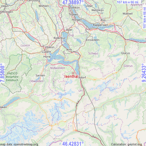
Isenthal GPS coordinates[2]
46° 54' 38.844" North, 8° 33' 40.356" East
| Map corner | latitude | longitude |
|---|---|---|
| Upper-left | 47.38897°, | 7.85808° |
| Center: | 46.91079°, | 8.56121° |
| Lower-right: | 46.42831°, | 9.26433° |
| Map W x H: | 106.8×106.8 km | = 66.4×66.4mi |
| max Lat: | 47.76737° ⇑68.9% North |
| Isenthal: | 46.91079° |
| min Lat: | ⇓31.1% South 45.83203° |
| min Long | Isenthal | max Long |
| 5.97153° | 8.56121° | 10.44624° |
| W 62.4%⇐ | ⇒37.6% E |
Elevation
Elevation of Isenthal is 784 m = 2572 ft, and this is 225.8 m = 741 ft above average elevation for this country.
| Max E: |
1845 m = 6053 ft | 11.7% |
| Isenthal | 784 m 2572 ft | |
| Avg. | 558.2 m = 1831 ft | |
Min E: |
197 m = 646 ft | 88.3% |
See also: Switzerland elevation on elevation.city.
Geographical zone
Isenthal is located in North temperate zone (between Tropic of Cancer and the Arctic Circle). Distance of this North polar circle is 2185.2 km =1357.8 mi to North.| Distance of | km | miles | from Isenthal |
|---|---|---|---|
| North Pole | 4791.1 | 2977.1 | to North |
| Arctic Circle | 2185.2 | 1357.8 | to North |
| Tropic Cancer | 2610.1 | 1621.8 | to South |
| Equator | 5216 | 3241.1 | to South |


Nearby cities:
15 places around Isenthal: (largest is in red/bold)
• Altdorf
7.2 km =4.5 mi,  118°
118°
• Attinghausen
7.5 km =4.7 mi,  135°
135°
• Bauen
3 km =1.9 mi,  25°
25°
• Beckenried
9 km =5.6 mi,  313°
313°
• Bürglen
8.8 km =5.5 mi, 116°
• Emmetten
6.2 km =3.9 mi,  325°
325°
• Erstfeld
12.3 km =7.6 mi,  146°
146°
• Flüelen
4.8 km =3 mi,  97°
97°
• Gersau
9.7 km =6 mi,  343°
343°
• Ingenbohl
10.6 km =6.6 mi,  22°
22°
• Morschach
9.1 km =5.7 mi, 28°
• Schattdorf
8.7 km =5.4 mi,  125°
125°
• Seedorf
5.3 km =3.3 mi, 127°
• Seelisberg
7.2 km =4.5 mi, 15°
• Vitznau
12.5 km =7.8 mi, 332°
Sources, notices
• [Note1] Compared only with cities in Switzerland existing in our database
• [Src1] Map data: © OpenStreetMap contributors (CC-BY-SA)
• [Src2] Other city data from geonames.org with taken over terms of usage.
• [Src3] Geographical zone / Annual Mean Temperature by Robert A. Rohde @ Wikipedia
