Seedorf geodata
Seedorf (Uri) is a populated place; located in Switzerland in Europe/Zurich (GMT+2) time zone. With population of 1,522 people, there are 1025 cities with bigger population in this country. Compared to other cities in Switzerland, 70.4% of cities are located further ↑North; 67.8% of cities are located further ←West and 65.3% of cities have higher elevation than Seedorf. Note1


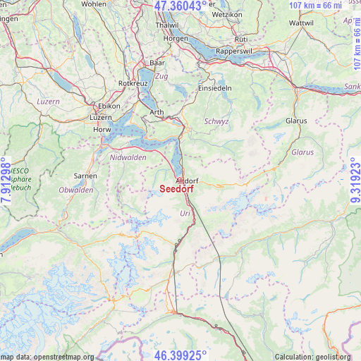
Seedorf GPS coordinates[2]
46° 52' 55.164" North, 8° 36' 57.996" East
| Map corner | latitude | longitude |
|---|---|---|
| Upper-left | 47.36043°, | 7.91298° |
| Center: | 46.88199°, | 8.61611° |
| Lower-right: | 46.39925°, | 9.31923° |
| Map W x H: | 106.9×106.9 km | = 66.4×66.4mi |
| max Lat: | 47.76737° ⇑70.4% North |
| Seedorf: | 46.88199° |
| min Lat: | ⇓29.6% South 45.83203° |
| min Long | Seedorf | max Long |
| 5.97153° | 8.61611° | 10.44624° |
| W 67.8%⇐ | ⇒32.2% E |
Elevation
Elevation of Seedorf is 446 m = 1463 ft, and this is 112.2 m = 368 ft below average elevation for this country.
| Max E: |
1845 m = 6053 ft | 65.3% |
| Avg. | 558.2 m = 1831 ft | |
| Seedorf | 446 m = 1463 ft | |
Min E: |
197 m = 646 ft | 34.7% |
See also: Switzerland elevation on elevation.city.
Geographical zone
Seedorf is located in North temperate zone (between Tropic of Cancer and the Arctic Circle). Distance of this North polar circle is 2188.4 km =1359.8 mi to North.| Distance of | km | miles | from Seedorf |
|---|---|---|---|
| North Pole | 4794.3 | 2979 | to North |
| Arctic Circle | 2188.4 | 1359.8 | to North |
| Tropic Cancer | 2606.9 | 1619.9 | to South |
| Equator | 5212.8 | 3239.1 | to South |


Nearby cities:
15 places around Seedorf: (largest is in red/bold)
• Altdorf
2.2 km =1.4 mi,  94°
94°
• Attinghausen
2.4 km =1.5 mi,  153°
153°
• Bauen
6.6 km =4.1 mi,  334°
334°
• Bürglen
3.8 km =2.4 mi,  100°
100°
• Emmetten
11.3 km =7 mi,  317°
317°
• Erstfeld
7.5 km =4.7 mi,  159°
159°
• Flüelen
2.6 km =1.6 mi,  13°
13°
• Ingenbohl
13 km =8.1 mi,  359°
359°
• Isenthal
5.3 km =3.3 mi,  307°
307°
• Morschach
11.2 km =7 mi,  0°
0°
• Schattdorf
3.5 km =2.2 mi,  122°
122°
• Seelisberg
10.4 km =6.5 mi,  347°
347°
• Silenen
11.2 km =7 mi, 157°
• Spiringen
8.7 km =5.4 mi, 96°
• Unterschächen
11.8 km =7.3 mi, 100°
Sources, notices
• [Note1] Compared only with cities in Switzerland existing in our database
• [Src1] Map data: © OpenStreetMap contributors (CC-BY-SA)
• [Src2] Other city data from geonames.org with taken over terms of usage.
• [Src3] Geographical zone / Annual Mean Temperature by Robert A. Rohde @ Wikipedia
