Siglistorf geodata
Siglistorf (Aargau) is a populated place; located in Switzerland in Europe/Zurich (GMT+2) time zone. With population of 569 people, there are 1730 cities with bigger population in this country. Compared to other cities in Switzerland, 94.5% of cities are located further ↓South; 51.3% of cities are located further →East and 65.3% of cities have higher elevation than Siglistorf. Note1


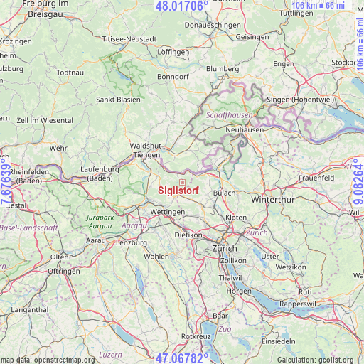
Siglistorf GPS coordinates[2]
47° 32' 40.524" North, 8° 22' 46.272" East
| Map corner | latitude | longitude |
|---|---|---|
| Upper-left | 48.01706°, | 7.67639° |
| Center: | 47.54459°, | 8.37952° |
| Lower-right: | 47.06782°, | 9.08264° |
| Map W x H: | 105.5×105.5 km | = 65.6×65.6mi |
| max Lat: | 47.76737° ⇑5.5% North |
| Siglistorf: | 47.54459° |
| min Lat: | ⇓94.5% South 45.83203° |
| min Long | Siglistorf | max Long |
| 5.97153° | 8.37952° | 10.44624° |
| W 48.7%⇐ | ⇒51.3% E |
Elevation
Elevation of Siglistorf is 446 m = 1463 ft, and this is 112.2 m = 368 ft below average elevation for this country.
| Max E: |
1845 m = 6053 ft | 65.3% |
| Avg. | 558.2 m = 1831 ft | |
| Siglistorf | 446 m = 1463 ft | |
Min E: |
197 m = 646 ft | 34.7% |
See also: Switzerland elevation on elevation.city.
Geographical zone
Siglistorf is located in North temperate zone (between Tropic of Cancer and the Arctic Circle). Distance of this North polar circle is 2114.7 km =1314 mi to North.| Distance of | km | miles | from Siglistorf |
|---|---|---|---|
| North Pole | 4720.6 | 2933.2 | to North |
| Arctic Circle | 2114.7 | 1314 | to North |
| Tropic Cancer | 2680.5 | 1665.6 | to South |
| Equator | 5286.5 | 3284.9 | to South |


Nearby cities:
15 places around Siglistorf: (largest is in red/bold)
• Bad Zurzach
8 km =5 mi,  306°
306°
• Ehrendingen
5.3 km =3.3 mi,  207°
207°
• Endingen
6.7 km =4.2 mi,  263°
263°
• Neerach
7.8 km =4.8 mi,  118°
118°
• Niederweningen / Niederweningen (Dorf)
4.3 km =2.7 mi,  182°
182°
• Oberweningen
5.1 km =3.2 mi,  156°
156°
• Rekingen
5.5 km =3.4 mi,  303°
303°
• Riedt
8.4 km =5.2 mi,  125°
125°
• Schibler
8.3 km =5.2 mi,  139°
139°
• Stadel
6.5 km =4 mi,  104°
104°
• Steinmaur
7.6 km =4.7 mi, 134°
• Steinmaur / Nieder-Steinmaur
7.8 km =4.8 mi, 137°
• Tegerfelden
6.9 km =4.3 mi,  282°
282°
• Weiach
4.4 km =2.7 mi,  68°
68°
• Weiach / Weiach (Dorfkern)
4.6 km =2.9 mi, 73°
Sources, notices
• [Note1] Compared only with cities in Switzerland existing in our database
• [Src1] Map data: © OpenStreetMap contributors (CC-BY-SA)
• [Src2] Other city data from geonames.org with taken over terms of usage.
• [Src3] Geographical zone / Annual Mean Temperature by Robert A. Rohde @ Wikipedia
