Unterägeri geodata
Unterägeri (Zug) is a populated place; located in Switzerland in Europe/Zurich (GMT+2) time zone. With population of 7,973 people, there are 198 cities with bigger population in this country. Compared to other cities in Switzerland, 57% of cities are located further ↑North; 64.6% of cities are located further ←West and 84.3% of cities have lower elevation than Unterägeri. Note1


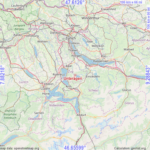
Unterägeri GPS coordinates[2]
47° 8' 11.22" North, 8° 35' 7.08" East
| Map corner | latitude | longitude |
|---|---|---|
| Upper-left | 47.6126°, | 7.88218° |
| Center: | 47.13645°, | 8.5853° |
| Lower-right: | 46.65599°, | 9.28843° |
| Map W x H: | 106.4×106.4 km | = 66.1×66.1mi |
| max Lat: | 47.76737° ⇑57% North |
| Unterägeri: | 47.13645° |
| min Lat: | ⇓43% South 45.83203° |
| min Long | Unterägeri | max Long |
| 5.97153° | 8.5853° | 10.44624° |
| W 64.6%⇐ | ⇒35.4% E |
Elevation
Elevation of Unterägeri is 727 m = 2385 ft, and this is 168.8 m = 554 ft above average elevation for this country.
| Max E: |
1845 m = 6053 ft | 15.7% |
| Unterägeri | 727 m 2385 ft | |
| Avg. | 558.2 m = 1831 ft | |
Min E: |
197 m = 646 ft | 84.3% |
See also: Switzerland elevation on elevation.city.
Geographical zone
Unterägeri is located in North temperate zone (between Tropic of Cancer and the Arctic Circle). Distance of this North polar circle is 2160.1 km =1342.2 mi to North.| Distance of | km | miles | from Unterägeri |
|---|---|---|---|
| North Pole | 4766 | 2961.5 | to North |
| Arctic Circle | 2160.1 | 1342.2 | to North |
| Tropic Cancer | 2635.2 | 1637.4 | to South |
| Equator | 5241.1 | 3256.7 | to South |


Nearby cities:
15 places around Unterägeri: (largest is in red/bold)
• Arth
9.4 km =5.8 mi,  209°
209°
• Baar
7.9 km =4.9 mi,  327°
327°
• Cham
10.5 km =6.5 mi,  298°
298°
• Goldau
10.3 km =6.4 mi,  196°
196°
• Meierskappel
10.9 km =6.8 mi,  263°
263°
• Menzingen
4.6 km =2.9 mi,  6°
6°
• Rothenthurm
7.7 km =4.8 mi,  117°
117°
• Samstagern
9.5 km =5.9 mi,  49°
49°
• Sattel
7.1 km =4.4 mi,  147°
147°
• Schindellegi
10.6 km =6.6 mi,  66°
66°
• Steinen
9.9 km =6.2 mi,  168°
168°
• Steinerberg
9.1 km =5.7 mi,  179°
179°
• Steinhausen
10 km =6.2 mi,  310°
310°
• Walchwil
6.5 km =4 mi,  233°
233°
• Zug
6.5 km =4 mi, 307°
Sources, notices
• [Note1] Compared only with cities in Switzerland existing in our database
• [Src1] Map data: © OpenStreetMap contributors (CC-BY-SA)
• [Src2] Other city data from geonames.org with taken over terms of usage.
• [Src3] Geographical zone / Annual Mean Temperature by Robert A. Rohde @ Wikipedia
