Steinerberg geodata
Steinerberg (Schwyz) is a populated place; located in Switzerland in Europe/Zurich (GMT+2) time zone. With population of 898 people, there are 1417 cities with bigger population in this country. Compared to other cities in Switzerland, 61.5% of cities are located further ↑North; 64.7% of cities are located further ←West and 77.7% of cities have lower elevation than Steinerberg. Note1


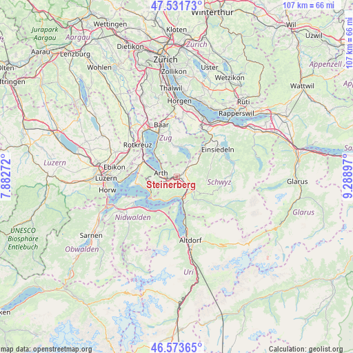
Steinerberg GPS coordinates[2]
47° 3' 17.424" North, 8° 35' 9.024" East
| Map corner | latitude | longitude |
|---|---|---|
| Upper-left | 47.53173°, | 7.88272° |
| Center: | 47.05484°, | 8.58584° |
| Lower-right: | 46.57365°, | 9.28897° |
| Map W x H: | 106.5×106.5 km | = 66.2×66.2mi |
| max Lat: | 47.76737° ⇑61.5% North |
| Steinerberg: | 47.05484° |
| min Lat: | ⇓38.5% South 45.83203° |
| min Long | Steinerberg | max Long |
| 5.97153° | 8.58584° | 10.44624° |
| W 64.7%⇐ | ⇒35.3% E |
Elevation
Elevation of Steinerberg is 639 m = 2096 ft, and this is 80.8 m = 265 ft above average elevation for this country.
| Max E: |
1845 m = 6053 ft | 22.3% |
| Steinerberg | 639 m 2096 ft | |
| Avg. | 558.2 m = 1831 ft | |
Min E: |
197 m = 646 ft | 77.7% |
See also: Switzerland elevation on elevation.city.
Geographical zone
Steinerberg is located in North temperate zone (between Tropic of Cancer and the Arctic Circle). Distance of this North polar circle is 2169.2 km =1347.9 mi to North.| Distance of | km | miles | from Steinerberg |
|---|---|---|---|
| North Pole | 4775.1 | 2967.1 | to North |
| Arctic Circle | 2169.2 | 1347.9 | to North |
| Tropic Cancer | 2626.1 | 1631.8 | to South |
| Equator | 5232 | 3251 | to South |


Nearby cities:
15 places around Steinerberg: (largest is in red/bold)
• Arth
4.8 km =3 mi,  281°
281°
• Gersau
8.2 km =5.1 mi,  214°
214°
• Goldau
3.1 km =1.9 mi,  255°
255°
• Ibach
6.6 km =4.1 mi,  137°
137°
• Ingenbohl
6.6 km =4.1 mi,  160°
160°
• Lauerz
2.4 km =1.5 mi,  184°
184°
• Morschach
8.4 km =5.2 mi, 162°
• Rothenthurm
8.8 km =5.5 mi,  51°
51°
• Sattel
4.9 km =3 mi, 50°
• Schwyz
6.4 km =4 mi,  126°
126°
• Seelisberg
9.1 km =5.7 mi, 179°
• Steinen
2.1 km =1.3 mi,  105°
105°
• Unterägeri
9.1 km =5.7 mi,  359°
359°
• Vitznau
9.2 km =5.7 mi,  237°
237°
• Walchwil
7.4 km =4.6 mi,  314°
314°
Sources, notices
• [Note1] Compared only with cities in Switzerland existing in our database
• [Src1] Map data: © OpenStreetMap contributors (CC-BY-SA)
• [Src2] Other city data from geonames.org with taken over terms of usage.
• [Src3] Geographical zone / Annual Mean Temperature by Robert A. Rohde @ Wikipedia
