Sattel geodata
Sattel (Schwyz) is a populated place; located in Switzerland in Europe/Zurich (GMT+2) time zone. With population of 1,597 people, there are 983 cities with bigger population in this country. Compared to other cities in Switzerland, 60% of cities are located further ↑North; 69.4% of cities are located further ←West and 89.4% of cities have lower elevation than Sattel. Note1


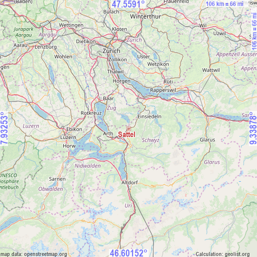
Sattel GPS coordinates[2]
47° 4' 56.856" North, 8° 38' 8.34" East
| Map corner | latitude | longitude |
|---|---|---|
| Upper-left | 47.5591°, | 7.93253° |
| Center: | 47.08246°, | 8.63565° |
| Lower-right: | 46.60152°, | 9.33878° |
| Map W x H: | 106.5×106.5 km | = 66.2×66.2mi |
| max Lat: | 47.76737° ⇑60% North |
| Sattel: | 47.08246° |
| min Lat: | ⇓40% South 45.83203° |
| min Long | Sattel | max Long |
| 5.97153° | 8.63565° | 10.44624° |
| W 69.4%⇐ | ⇒30.6% E |
Elevation
Elevation of Sattel is 811 m = 2661 ft, and this is 252.8 m = 829 ft above average elevation for this country.
| Max E: |
1845 m = 6053 ft | 10.6% |
| Sattel | 811 m 2661 ft | |
| Avg. | 558.2 m = 1831 ft | |
Min E: |
197 m = 646 ft | 89.4% |
See also: Switzerland elevation on elevation.city.
Geographical zone
Sattel is located in North temperate zone (between Tropic of Cancer and the Arctic Circle). Distance of this North polar circle is 2166.1 km =1346 mi to North.| Distance of | km | miles | from Sattel |
|---|---|---|---|
| North Pole | 4772 | 2965.2 | to North |
| Arctic Circle | 2166.1 | 1346 | to North |
| Tropic Cancer | 2629.2 | 1633.7 | to South |
| Equator | 5235.1 | 3252.9 | to South |


Nearby cities:
15 places around Sattel: (largest is in red/bold)
• Alpthal
6.3 km =3.9 mi,  103°
103°
• Arth
8.8 km =5.5 mi,  255°
255°
• Einsiedeln
9.9 km =6.2 mi,  58°
58°
• Goldau
7.8 km =4.8 mi,  240°
240°
• Ibach
8 km =5 mi,  174°
174°
• Ingenbohl
9.4 km =5.8 mi,  189°
189°
• Lauerz
6.8 km =4.2 mi,  215°
215°
• Menzingen
11.1 km =6.9 mi,  342°
342°
• Morschach
11.2 km =7 mi, 186°
• Rothenthurm
3.9 km =2.4 mi,  51°
51°
• Schwyz
7 km =4.3 mi, 168°
• Steinen
4 km =2.5 mi,  206°
206°
• Steinerberg
4.9 km =3 mi,  230°
230°
• Unterägeri
7.1 km =4.4 mi,  327°
327°
• Walchwil
9.2 km =5.7 mi,  283°
283°
Sources, notices
• [Note1] Compared only with cities in Switzerland existing in our database
• [Src1] Map data: © OpenStreetMap contributors (CC-BY-SA)
• [Src2] Other city data from geonames.org with taken over terms of usage.
• [Src3] Geographical zone / Annual Mean Temperature by Robert A. Rohde @ Wikipedia
