Travers geodata
Travers (Neuchâtel) is a populated place; located in Switzerland in Europe/Zurich (GMT+2) time zone. With population of 1,233 people, there are 1174 cities with bigger population in this country. Compared to other cities in Switzerland, 67.5% of cities are located further ↑North; 92.8% of cities are located further →East and 84.8% of cities have lower elevation than Travers. Note1
Administrative division(s):
- Level 1: Neuchâtel
- Level 2: Val-de-Travers District
- Level 3: Val-de-Travers


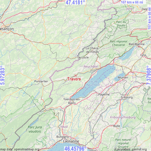
Travers GPS coordinates[2]
46° 56' 24.648" North, 6° 40' 33.42" East
| Map corner | latitude | longitude |
|---|---|---|
| Upper-left | 47.4181°, | 5.97283° |
| Center: | 46.94018°, | 6.67595° |
| Lower-right: | 46.45796°, | 7.37908° |
| Map W x H: | 106.8×106.8 km | = 66.4×66.4mi |
| max Lat: | 47.76737° ⇑67.5% North |
| Travers: | 46.94018° |
| min Lat: | ⇓32.5% South 45.83203° |
| min Long | Travers | max Long |
| 5.97153° | 6.67595° | 10.44624° |
| W 7.2%⇐ | ⇒92.8% E |
Elevation
Elevation of Travers is 732 m = 2402 ft, and this is 173.8 m = 570 ft above average elevation for this country.
| Max E: |
1845 m = 6053 ft | 15.2% |
| Travers | 732 m 2402 ft | |
| Avg. | 558.2 m = 1831 ft | |
Min E: |
197 m = 646 ft | 84.8% |
See also: Switzerland elevation on elevation.city.
Geographical zone
Travers is located in North temperate zone (between Tropic of Cancer and the Arctic Circle). Distance of this North polar circle is 2181.9 km =1355.8 mi to North.| Distance of | km | miles | from Travers |
|---|---|---|---|
| North Pole | 4787.8 | 2975 | to North |
| Arctic Circle | 2181.9 | 1355.8 | to North |
| Tropic Cancer | 2613.3 | 1623.8 | to South |
| Equator | 5219.3 | 3243.1 | to South |


Nearby cities:
15 places around Travers: (largest is in red/bold)
• Bevaix
10.6 km =6.6 mi,  96°
96°
• Buttes
11.1 km =6.9 mi,  238°
238°
• Champagne
12.1 km =7.5 mi,  185°
185°
• Concise
10.5 km =6.5 mi,  161°
161°
• Couvet
3.7 km =2.3 mi, 243°
• Fleurier
8.3 km =5.2 mi, 239°
• Gorgier
9 km =5.6 mi,  118°
118°
• La Brévine
6.9 km =4.3 mi,  310°
310°
• Les Ponts-de-Martel
7.6 km =4.7 mi,  33°
33°
• Môtiers
5.9 km =3.7 mi, 236°
• Noiraigue
4.1 km =2.5 mi,  64°
64°
• Rochefort
10.9 km =6.8 mi,  67°
67°
• Saint-Aubin-Sauges
8.9 km =5.5 mi, 124°
• Saint-Sulpice
9.2 km =5.7 mi,  249°
249°
• Villars-Burquin
10.8 km =6.7 mi,  199°
199°
Sources, notices
• [Note1] Compared only with cities in Switzerland existing in our database
• [Src1] Map data: © OpenStreetMap contributors (CC-BY-SA)
• [Src2] Other city data from geonames.org with taken over terms of usage.
• [Src3] Geographical zone / Annual Mean Temperature by Robert A. Rohde @ Wikipedia
