Rochefort geodata
Rochefort (Neuchâtel) is a seat of a third-order administrative division; located in Switzerland in Europe/Zurich (GMT+2) time zone. In our database, there are 1823 cities with bigger population. Compared to other cities in Switzerland, 65.5% of cities are located further ↑North; 91.5% of cities are located further →East and 87.7% of cities have lower elevation than Rochefort. Note1


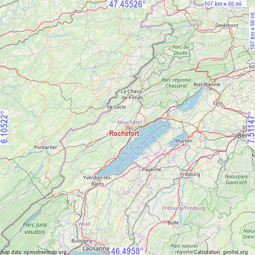
Rochefort GPS coordinates[2]
46° 58' 39.648" North, 6° 48' 30.06" East
| Map corner | latitude | longitude |
|---|---|---|
| Upper-left | 47.45526°, | 6.10522° |
| Center: | 46.97768°, | 6.80835° |
| Lower-right: | 46.4958°, | 7.51147° |
| Map W x H: | 106.7×106.7 km | = 66.3×66.3mi |
| max Lat: | 47.76737° ⇑65.5% North |
| Rochefort: | 46.97768° |
| min Lat: | ⇓34.5% South 45.83203° |
| min Long | Rochefort | max Long |
| 5.97153° | 6.80835° | 10.44624° |
| W 8.5%⇐ | ⇒91.5% E |
Elevation
Elevation of Rochefort is 775 m = 2543 ft, and this is 216.8 m = 711 ft above average elevation for this country.
| Max E: |
1845 m = 6053 ft | 12.3% |
| Rochefort | 775 m 2543 ft | |
| Avg. | 558.2 m = 1831 ft | |
Min E: |
197 m = 646 ft | 87.7% |
See also: Switzerland elevation on elevation.city.
Geographical zone
Rochefort is located in North temperate zone (between Tropic of Cancer and the Arctic Circle). Distance of this North polar circle is 2177.7 km =1353.2 mi to North.| Distance of | km | miles | from Rochefort |
|---|---|---|---|
| North Pole | 4783.6 | 2972.4 | to North |
| Arctic Circle | 2177.7 | 1353.2 | to North |
| Tropic Cancer | 2617.5 | 1626.4 | to South |
| Equator | 5223.4 | 3245.7 | to South |


Nearby cities:
15 places around Rochefort: (largest is in red/bold)
• Auvernier
5.4 km =3.4 mi,  92°
92°
• Bevaix
5.4 km =3.4 mi,  174°
174°
• Boudevilliers
8.2 km =5.1 mi,  48°
48°
• Boudry
3.8 km =2.4 mi,  144°
144°
• Cortaillod
4.7 km =2.9 mi, 144°
• Fontainemelon
10.4 km =6.5 mi,  34°
34°
• Gorgier
8.7 km =5.4 mi,  194°
194°
• La Sagne
7.6 km =4.7 mi,  0°
0°
• Le Locle
9.8 km =6.1 mi,  332°
332°
• Les Geneveys-sur-Coffrane
5.3 km =3.3 mi,  37°
37°
• Les Ponts-de-Martel
6.3 km =3.9 mi,  290°
290°
• Neuchâtel
9.4 km =5.8 mi,  80°
80°
• Noiraigue
6.8 km =4.2 mi,  249°
249°
• Peseux
6.2 km =3.9 mi, 80°
• Saint-Aubin-Sauges
9.7 km =6 mi,  196°
196°
Sources, notices
• [Note1] Compared only with cities in Switzerland existing in our database
• [Src1] Map data: © OpenStreetMap contributors (CC-BY-SA)
• [Src2] Other city data from geonames.org with taken over terms of usage.
• [Src3] Geographical zone / Annual Mean Temperature by Robert A. Rohde @ Wikipedia
