La Brévine geodata
La Brévine (Neuchâtel) is a populated place; located in Switzerland in Europe/Zurich (GMT+2) time zone. With population of 723 people, there are 1568 cities with bigger population in this country. Compared to other cities in Switzerland, 65.3% of cities are located further ↑North; 94% of cities are located further →East and 95.8% of cities have lower elevation than La Brévine. Note1


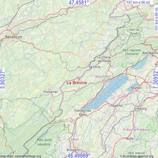
La Brévine GPS coordinates[2]
46° 58' 49.98" North, 6° 36' 23.004" East
| Map corner | latitude | longitude |
|---|---|---|
| Upper-left | 47.4581°, | 5.90327° |
| Center: | 46.98055°, | 6.60639° |
| Lower-right: | 46.49869°, | 7.30952° |
| Map W x H: | 106.7×106.7 km | = 66.3×66.3mi |
| max Lat: | 47.76737° ⇑65.3% North |
| La Brévine: | 46.98055° |
| min Lat: | ⇓34.7% South 45.83203° |
| min Long | La Brévine | max Long |
| 5.97153° | 6.60639° | 10.44624° |
| W 6%⇐ | ⇒94% E |
Elevation
Elevation of La Brévine is 1044 m = 3425 ft, and this is 485.8 m = 1594 ft above average elevation for this country.
| Max E: |
1845 m = 6053 ft | 4.2% |
| La Brévine | 1044 m 3425 ft | |
| Avg. | 558.2 m = 1831 ft | |
Min E: |
197 m = 646 ft | 95.8% |
See also: Switzerland elevation on elevation.city.
Geographical zone
La Brévine is located in North temperate zone (between Tropic of Cancer and the Arctic Circle). Distance of this North polar circle is 2177.4 km =1353 mi to North.| Distance of | km | miles | from La Brévine |
|---|---|---|---|
| North Pole | 4783.3 | 2972.2 | to North |
| Arctic Circle | 2177.4 | 1353 | to North |
| Tropic Cancer | 2617.8 | 1626.6 | to South |
| Equator | 5223.7 | 3245.9 | to South |


Nearby cities:
15 places around La Brévine: (largest is in red/bold)
• Buttes
11.1 km =6.9 mi,  202°
202°
• Couvet
6.5 km =4 mi,  162°
162°
• Fleurier
8.9 km =5.5 mi,  191°
191°
• Gorgier
15.8 km =9.8 mi,  123°
123°
• La Côte-aux-Fées
15.4 km =9.6 mi,  214°
214°
• Le Locle
13.7 km =8.5 mi,  52°
52°
• Les Brenets
12.2 km =7.6 mi,  37°
37°
• Les Ponts-de-Martel
9.6 km =6 mi,  78°
78°
• Les Verrières
12.8 km =8 mi,  228°
228°
• Môtiers
7.7 km =4.8 mi,  177°
177°
• Noiraigue
9.4 km =5.8 mi,  106°
106°
• Rochefort
15.3 km =9.5 mi,  91°
91°
• Saint-Sulpice
8.4 km =5.2 mi, 203°
• Travers
6.9 km =4.3 mi,  130°
130°
• Villars-Burquin
14.7 km =9.1 mi,  173°
173°
Sources, notices
• [Note1] Compared only with cities in Switzerland existing in our database
• [Src1] Map data: © OpenStreetMap contributors (CC-BY-SA)
• [Src2] Other city data from geonames.org with taken over terms of usage.
• [Src3] Geographical zone / Annual Mean Temperature by Robert A. Rohde @ Wikipedia
