Stampa geodata
Stampa (Grisons) is a populated place; located in Switzerland in Europe/Zurich (GMT+2) time zone. With population of 588 people, there are 1705 cities with bigger population in this country. Compared to other cities in Switzerland, 88.9% of cities are located further ↑North; 98.2% of cities are located further ←West and 94.9% of cities have lower elevation than Stampa. Note1


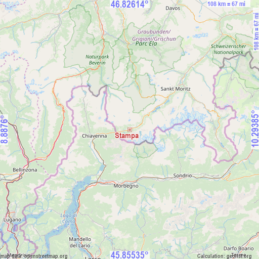
Stampa GPS coordinates[2]
46° 20' 34.44" North, 9° 35' 26.592" East
| Map corner | latitude | longitude |
|---|---|---|
| Upper-left | 46.82614°, | 8.8876° |
| Center: | 46.3429°, | 9.59072° |
| Lower-right: | 45.85535°, | 10.29385° |
| Map W x H: | 107.9×107.9 km | = 67×67mi |
| max Lat: | 47.76737° ⇑88.9% North |
| Stampa: | 46.3429° |
| min Lat: | ⇓11.1% South 45.83203° |
| min Long | Stampa | max Long |
| 5.97153° | 9.59072° | 10.44624° |
| W 98.2%⇐ | ⇒1.8% E |
Elevation
Elevation of Stampa is 1005 m = 3297 ft, and this is 446.8 m = 1466 ft above average elevation for this country.
| Max E: |
1845 m = 6053 ft | 5.1% |
| Stampa | 1005 m 3297 ft | |
| Avg. | 558.2 m = 1831 ft | |
Min E: |
197 m = 646 ft | 94.9% |
See also: Switzerland elevation on elevation.city.
Geographical zone
Stampa is located in North temperate zone (between Tropic of Cancer and the Arctic Circle). Distance of this North polar circle is 2248.3 km =1397 mi to North.| Distance of | km | miles | from Stampa |
|---|---|---|---|
| North Pole | 4854.2 | 3016.3 | to North |
| Arctic Circle | 2248.3 | 1397 | to North |
| Tropic Cancer | 2546.9 | 1582.6 | to South |
| Equator | 5152.8 | 3201.8 | to South |


Nearby cities:
15 places around Stampa: (largest is in red/bold)
• Andeer
31.6 km =19.6 mi,  336°
336°
• Bergün
34 km =21.1 mi,  20°
20°
• Celerina
27.8 km =17.3 mi,  47°
47°
• Donat
34.1 km =21.2 mi, 338°
• Lostallo
30.4 km =18.9 mi,  263°
263°
• Mesocco
28 km =17.4 mi,  281°
281°
• Pontresina
29.2 km =18.1 mi, 54°
• Promontogno
2.6 km =1.6 mi, 261°
• Samedan
30.3 km =18.8 mi, 45°
• Santa Maria in Calanca
35.4 km =22 mi, 255°
• Savognin
28.3 km =17.6 mi,  1°
1°
• Sils-Segl Maria
16.3 km =10.1 mi, 54°
• Silvaplana
20.2 km =12.6 mi, 50°
• St. Moritz
26 km =16.2 mi, 48°
• Tiefencastel
35.3 km =21.9 mi,  358°
358°
Sources, notices
• [Note1] Compared only with cities in Switzerland existing in our database
• [Src1] Map data: © OpenStreetMap contributors (CC-BY-SA)
• [Src2] Other city data from geonames.org with taken over terms of usage.
• [Src3] Geographical zone / Annual Mean Temperature by Robert A. Rohde @ Wikipedia
