Pontresina geodata
Pontresina (Grisons) is a populated place; located in Switzerland in Europe/Zurich (GMT+2) time zone. With population of 1,863 people, there are 883 cities with bigger population in this country. Compared to other cities in Switzerland, 85.7% of cities are located further ↑North; 99.5% of cities are located further ←West and 99.9% of cities have lower elevation than Pontresina. Note1


Pontresina GPS coordinates[2]
46° 29' 43.8" North, 9° 54' 4.536" East
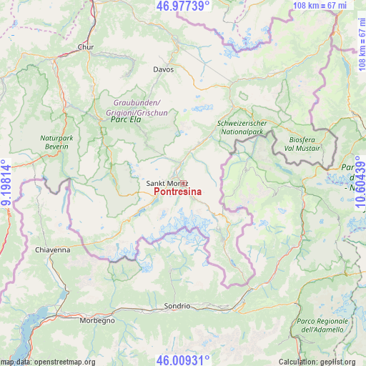
| Map corner | latitude | longitude |
|---|---|---|
| Upper-left | 46.97739°, | 9.19814° |
| Center: | 46.4955°, | 9.90126° |
| Lower-right: | 46.00931°, | 10.60439° |
| Map W x H: | 107.6×107.6 km | = 66.9×66.9mi |
| max Lat: | 47.76737° ⇑85.7% North |
| Pontresina: | 46.4955° |
| min Lat: | ⇓14.3% South 45.83203° |
| min Long | Pontresina | max Long |
| 5.97153° | 9.90126° | 10.44624° |
| W 99.5%⇐ | ⇒0.5% E |
Elevation
Elevation of Pontresina is 1822 m = 5978 ft, and this is 1263.8 m = 4146 ft above average elevation for this country.
| Max E: |
1845 m = 6053 ft | 0.099999999999994% |
| Pontresina | 1822 m 5978 ft | |
| Avg. | 558.2 m = 1831 ft | |
Min E: |
197 m = 646 ft | 99.9% |
See also: Switzerland elevation on elevation.city.
Geographical zone
Pontresina is located in North temperate zone (between Tropic of Cancer and the Arctic Circle). Distance of this North polar circle is 2231.4 km =1386.5 mi to North.| Distance of | km | miles | from Pontresina |
|---|---|---|---|
| North Pole | 4837.2 | 3005.7 | to North |
| Arctic Circle | 2231.4 | 1386.5 | to North |
| Tropic Cancer | 2563.9 | 1593.1 | to South |
| Equator | 5169.8 | 3212.4 | to South |


Nearby cities:
15 places around Pontresina: (largest is in red/bold)
• Bergün
19 km =11.8 mi,  321°
321°
• Celerina
3.8 km =2.4 mi,  299°
299°
• Filisur
25.7 km =16 mi, 320°
• La Punt Chamues-ch
9.4 km =5.8 mi,  8°
8°
• Poschiavo
22.5 km =14 mi,  147°
147°
• Samedan
4.8 km =3 mi,  332°
332°
• Savognin
25.8 km =16 mi, 296°
• Scanfs
14.5 km =9 mi,  26°
26°
• Sils-Segl Maria
12.9 km =8 mi,  234°
234°
• Silvaplana
9.1 km =5.7 mi,  242°
242°
• St. Moritz
4.5 km =2.8 mi,  275°
275°
• Stampa
29.2 km =18.1 mi, 234°
• Tiefencastel
30.7 km =19.1 mi,  306°
306°
• Zernez
26.9 km =16.7 mi, 32°
• Zuoz
12.7 km =7.9 mi,  20°
20°
Sources, notices
• [Note1] Compared only with cities in Switzerland existing in our database
• [Src1] Map data: © OpenStreetMap contributors (CC-BY-SA)
• [Src2] Other city data from geonames.org with taken over terms of usage.
• [Src3] Geographical zone / Annual Mean Temperature by Robert A. Rohde @ Wikipedia
