Unterwasser geodata
Unterwasser (Saint Gallen) is a populated place; located in Switzerland in Europe/Zurich (GMT+2) time zone. With population of 685 people, there are 1615 cities with bigger population in this country. Compared to other cities in Switzerland, 53% of cities are located further ↑North; 94.1% of cities are located further ←West and 92.5% of cities have lower elevation than Unterwasser. Note1
Administrative division(s):
- Level 1: Saint Gallen
- Level 2: Wahlkreis Toggenburg
- Level 3: Wildhaus-Alt St. Johann


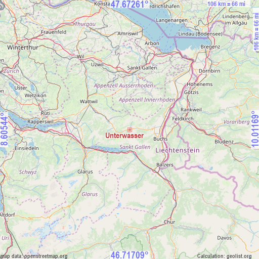
Unterwasser GPS coordinates[2]
47° 11' 49.2" North, 9° 18' 30.816" East
| Map corner | latitude | longitude |
|---|---|---|
| Upper-left | 47.67261°, | 8.60544° |
| Center: | 47.197°, | 9.30856° |
| Lower-right: | 46.71709°, | 10.01169° |
| Map W x H: | 106.2×106.2 km | = 66×66mi |
| max Lat: | 47.76737° ⇑53% North |
| Unterwasser: | 47.197° |
| min Lat: | ⇓47% South 45.83203° |
| min Long | Unterwasser | max Long |
| 5.97153° | 9.30856° | 10.44624° |
| W 94.1%⇐ | ⇒5.9% E |
Elevation
Elevation of Unterwasser is 907 m = 2976 ft, and this is 348.8 m = 1144 ft above average elevation for this country.
| Max E: |
1845 m = 6053 ft | 7.5% |
| Unterwasser | 907 m 2976 ft | |
| Avg. | 558.2 m = 1831 ft | |
Min E: |
197 m = 646 ft | 92.5% |
See also: Switzerland elevation on elevation.city.
Geographical zone
Unterwasser is located in North temperate zone (between Tropic of Cancer and the Arctic Circle). Distance of this North polar circle is 2153.4 km =1338.1 mi to North.| Distance of | km | miles | from Unterwasser |
|---|---|---|---|
| North Pole | 4759.2 | 2957.2 | to North |
| Arctic Circle | 2153.4 | 1338.1 | to North |
| Tropic Cancer | 2641.9 | 1641.6 | to South |
| Equator | 5247.8 | 3260.8 | to South |


Nearby cities:
15 places around Unterwasser: (largest is in red/bold)
• Amden
13.7 km =8.5 mi,  246°
246°
• Buchs
13.2 km =8.2 mi,  104°
104°
• Ebnat-Kappel
15.6 km =9.7 mi,  297°
297°
• Flums
12.1 km =7.5 mi,  167°
167°
• Gams
10.1 km =6.3 mi,  85°
85°
• Gonten
14.8 km =9.2 mi,  11°
11°
• Grabs
10.4 km =6.5 mi, 98°
• Haag (Rheintal)
13.7 km =8.5 mi,  84°
84°
• Hemberg
15.3 km =9.5 mi,  318°
318°
• Krummenau
11.8 km =7.3 mi, 298°
• Quarten
11.2 km =7 mi,  206°
206°
• Sevelen
15.8 km =9.8 mi,  121°
121°
• Urnäsch
13.5 km =8.4 mi,  350°
350°
• Walenstadt
8.1 km =5 mi,  178°
178°
• Wildhaus
3.6 km =2.2 mi,  74°
74°
Sources, notices
• [Note1] Compared only with cities in Switzerland existing in our database
• [Src1] Map data: © OpenStreetMap contributors (CC-BY-SA)
• [Src2] Other city data from geonames.org with taken over terms of usage.
• [Src3] Geographical zone / Annual Mean Temperature by Robert A. Rohde @ Wikipedia
