Wildhaus geodata
Wildhaus (Saint Gallen) is a populated place; located in Switzerland in Europe/Zurich (GMT+2) time zone. With population of 1,221 people, there are 1180 cities with bigger population in this country. Compared to other cities in Switzerland, 52.1% of cities are located further ↑North; 94.6% of cities are located further ←West and 96.4% of cities have lower elevation than Wildhaus. Note1
Administrative division(s):
- Level 1: Saint Gallen
- Level 2: Wahlkreis Toggenburg
- Level 3: Wildhaus-Alt St. Johann


Wildhaus GPS coordinates[2]
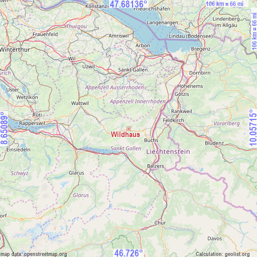
47° 12' 20.988" North, 9° 21' 14.472" East
| Map corner | latitude | longitude |
|---|---|---|
| Upper-left | 47.68136°, | 8.65089° |
| Center: | 47.20583°, | 9.35402° |
| Lower-right: | 46.726°, | 10.05715° |
| Map W x H: | 106.2×106.2 km | = 66×66mi |
| max Lat: | 47.76737° ⇑52.1% North |
| Wildhaus: | 47.20583° |
| min Lat: | ⇓47.9% South 45.83203° |
| min Long | Wildhaus | max Long |
| 5.97153° | 9.35402° | 10.44624° |
| W 94.6%⇐ | ⇒5.4% E |
Elevation
Elevation of Wildhaus is 1090 m = 3576 ft, and this is 531.8 m = 1745 ft above average elevation for this country.
| Max E: |
1845 m = 6053 ft | 3.6% |
| Wildhaus | 1090 m 3576 ft | |
| Avg. | 558.2 m = 1831 ft | |
Min E: |
197 m = 646 ft | 96.4% |
See also: Switzerland elevation on elevation.city.
Geographical zone
Wildhaus is located in North temperate zone (between Tropic of Cancer and the Arctic Circle). Distance of this North polar circle is 2152.4 km =1337.4 mi to North.| Distance of | km | miles | from Wildhaus |
|---|---|---|---|
| North Pole | 4758.3 | 2956.7 | to North |
| Arctic Circle | 2152.4 | 1337.4 | to North |
| Tropic Cancer | 2642.9 | 1642.2 | to South |
| Equator | 5248.8 | 3261.5 | to South |


Nearby cities:
15 places around Wildhaus: (largest is in red/bold)
• Appenzell
14.5 km =9 mi,  16°
16°
• Buchs
10.3 km =6.4 mi,  114°
114°
• Flums
12.8 km =8 mi,  183°
183°
• Gams
6.6 km =4.1 mi,  91°
91°
• Gonten
13.5 km =8.4 mi,  357°
357°
• Grabs
7.3 km =4.5 mi, 110°
• Haag (Rheintal)
10.2 km =6.3 mi, 87°
• Krummenau
14.6 km =9.1 mi,  288°
288°
• Quarten
13.9 km =8.6 mi,  217°
217°
• Rüthi
17.1 km =10.6 mi,  54°
54°
• Sennwald
12.8 km =8 mi,  61°
61°
• Sevelen
13.6 km =8.5 mi,  133°
133°
• Unterwasser
3.6 km =2.2 mi,  254°
254°
• Urnäsch
13.5 km =8.4 mi,  335°
335°
• Walenstadt
9.6 km =6 mi,  199°
199°
Sources, notices
• [Note1] Compared only with cities in Switzerland existing in our database
• [Src1] Map data: © OpenStreetMap contributors (CC-BY-SA)
• [Src2] Other city data from geonames.org with taken over terms of usage.
• [Src3] Geographical zone / Annual Mean Temperature by Robert A. Rohde @ Wikipedia
