Buchs geodata
Buchs (Aargau) is a seat of a third-order administrative division; located in Switzerland in Europe/Zurich (GMT+2) time zone. With population of 6,599 people, there are 250 cities with bigger population in this country. Compared to other cities in Switzerland, 72% of cities are located further ↓South; 58.3% of cities are located further →East and 92.2% of cities have higher elevation than Buchs. Note1


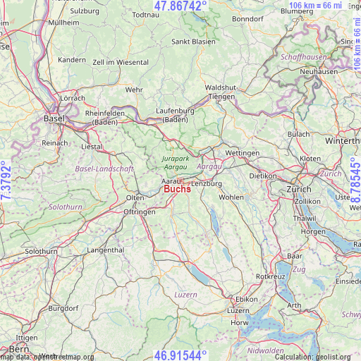
Buchs GPS coordinates[2]
47° 23' 36.888" North, 8° 4' 56.388" East
| Map corner | latitude | longitude |
|---|---|---|
| Upper-left | 47.86742°, | 7.3792° |
| Center: | 47.39358°, | 8.08233° |
| Lower-right: | 46.91544°, | 8.78545° |
| Map W x H: | 105.9×105.8 km | = 65.8×65.7mi |
| max Lat: | 47.76737° ⇑28% North |
| Buchs: | 47.39358° |
| min Lat: | ⇓72% South 45.83203° |
| min Long | Buchs | max Long |
| 5.97153° | 8.08233° | 10.44624° |
| W 41.7%⇐ | ⇒58.3% E |
Elevation
Elevation of Buchs is 385 m = 1263 ft, and this is 173.2 m = 568 ft below average elevation for this country.
| Max E: |
1845 m = 6053 ft | 92.2% |
| Avg. | 558.2 m = 1831 ft | |
| Buchs | 385 m = 1263 ft | |
Min E: |
197 m = 646 ft | 7.8% |
See also: Switzerland elevation on elevation.city.
Geographical zone
Buchs is located in North temperate zone (between Tropic of Cancer and the Arctic Circle). Distance of this North polar circle is 2131.5 km =1324.5 mi to North.| Distance of | km | miles | from Buchs |
|---|---|---|---|
| North Pole | 4737.4 | 2943.7 | to North |
| Arctic Circle | 2131.5 | 1324.5 | to North |
| Tropic Cancer | 2663.8 | 1655.2 | to South |
| Equator | 5269.7 | 3274.4 | to South |


Nearby cities:
15 places around Buchs: (largest is in red/bold)
• Aarau
2.9 km =1.8 mi,  267°
267°
• Biberstein
2.5 km =1.6 mi,  4°
4°
• Densbüren
6.9 km =4.3 mi,  341°
341°
• Erlinsbach
5.6 km =3.5 mi, 274°
• Gränichen
4.1 km =2.5 mi,  158°
158°
• Küttigen
3.4 km =2.1 mi,  313°
313°
• Muhen
6.7 km =4.2 mi,  197°
197°
• Oberentfelden
5 km =3.1 mi,  213°
213°
• Rupperswil
3.6 km =2.2 mi,  76°
76°
• Schafisheim
4.9 km =3 mi,  112°
112°
• Schönenwerd
6.7 km =4.2 mi,  245°
245°
• Staufen
6.5 km =4 mi,  101°
101°
• Suhr
2.4 km =1.5 mi,  184°
184°
• Thalheim
4.8 km =3 mi,  16°
16°
• Veltheim
6.9 km =4.3 mi,  44°
44°
Sources, notices
• [Note1] Compared only with cities in Switzerland existing in our database
• [Src1] Map data: © OpenStreetMap contributors (CC-BY-SA)
• [Src2] Other city data from geonames.org with taken over terms of usage.
• [Src3] Geographical zone / Annual Mean Temperature by Robert A. Rohde @ Wikipedia
