Servion geodata
Servion (Vaud) is a seat of a third-order administrative division; located in Switzerland in Europe/Zurich (GMT+2) time zone. In our database, there are 1823 cities with bigger population. Compared to other cities in Switzerland, 83.2% of cities are located further ↑North; 91.8% of cities are located further →East and 84.3% of cities have lower elevation than Servion. Note1


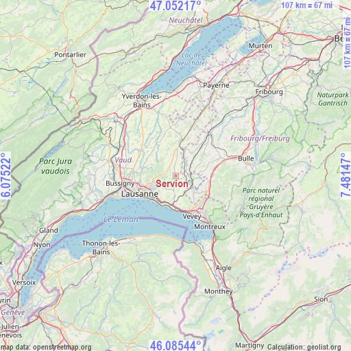
Servion GPS coordinates[2]
46° 34' 15.456" North, 6° 46' 42.06" East
| Map corner | latitude | longitude |
|---|---|---|
| Upper-left | 47.05217°, | 6.07522° |
| Center: | 46.57096°, | 6.77835° |
| Lower-right: | 46.08544°, | 7.48147° |
| Map W x H: | 107.5×107.5 km | = 66.8×66.8mi |
| max Lat: | 47.76737° ⇑83.2% North |
| Servion: | 46.57096° |
| min Lat: | ⇓16.8% South 45.83203° |
| min Long | Servion | max Long |
| 5.97153° | 6.77835° | 10.44624° |
| W 8.2%⇐ | ⇒91.8% E |
Elevation
Elevation of Servion is 727 m = 2385 ft, and this is 168.8 m = 554 ft above average elevation for this country.
| Max E: |
1845 m = 6053 ft | 15.7% |
| Servion | 727 m 2385 ft | |
| Avg. | 558.2 m = 1831 ft | |
Min E: |
197 m = 646 ft | 84.3% |
See also: Switzerland elevation on elevation.city.
Geographical zone
Servion is located in North temperate zone (between Tropic of Cancer and the Arctic Circle). Distance of this North polar circle is 2223 km =1381.3 mi to North.| Distance of | km | miles | from Servion |
|---|---|---|---|
| North Pole | 4828.9 | 3000.5 | to North |
| Arctic Circle | 2223 | 1381.3 | to North |
| Tropic Cancer | 2572.3 | 1598.4 | to South |
| Equator | 5178.2 | 3217.6 | to South |


Nearby cities:
15 places around Servion: (largest is in red/bold)
• Attalens
9.1 km =5.7 mi,  142°
142°
• Belmont-sur-Lausanne
9.7 km =6 mi,  233°
233°
• Chexbres
9.9 km =6.2 mi,  180°
180°
• Corcelles-le-Jorat
4.8 km =3 mi,  325°
325°
• Cully
9.9 km =6.2 mi,  202°
202°
• Ecublens
4.7 km =2.9 mi,  30°
30°
• Epalinges
8.8 km =5.5 mi,  253°
253°
• Froideville
8.2 km =5.1 mi,  294°
294°
• Maracon
7.5 km =4.7 mi,  107°
107°
• Oron-la-Ville
3.6 km =2.2 mi,  90°
90°
• Palézieux
5.7 km =3.5 mi,  124°
124°
• Puidoux
7.8 km =4.8 mi, 177°
• Rue
6.3 km =3.9 mi, 32°
• Savigny
5.1 km =3.2 mi,  224°
224°
• Sottens
9.8 km =6.1 mi,  343°
343°
Sources, notices
• [Note1] Compared only with cities in Switzerland existing in our database
• [Src1] Map data: © OpenStreetMap contributors (CC-BY-SA)
• [Src2] Other city data from geonames.org with taken over terms of usage.
• [Src3] Geographical zone / Annual Mean Temperature by Robert A. Rohde @ Wikipedia
