Corcelles-le-Jorat geodata
Corcelles-le-Jorat (Vaud) is a seat of a third-order administrative division; located in Switzerland in Europe/Zurich (GMT+2) time zone. In our database, there are 1823 cities with bigger population. Compared to other cities in Switzerland, 82.2% of cities are located further ↑North; 92.1% of cities are located further →East and 84.9% of cities have lower elevation than Corcelles-le-Jorat. Note1


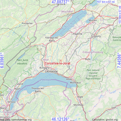
Corcelles-le-Jorat GPS coordinates[2]
46° 36' 23.292" North, 6° 44' 33.828" East
| Map corner | latitude | longitude |
|---|---|---|
| Upper-left | 47.08737°, | 6.03961° |
| Center: | 46.60647°, | 6.74273° |
| Lower-right: | 46.12126°, | 7.44586° |
| Map W x H: | 107.4×107.4 km | = 66.7×66.7mi |
| max Lat: | 47.76737° ⇑82.2% North |
| Corcelles-le-Jorat: | 46.60647° |
| min Lat: | ⇓17.8% South 45.83203° |
| min Long | Corcelles-le-Jo | max Long |
| 5.97153° | 6.74273° | 10.44624° |
| W 7.9%⇐ | ⇒92.1% E |
Elevation
Elevation of Corcelles-le-Jorat is 734 m = 2408 ft, and this is 175.8 m = 577 ft above average elevation for this country.
| Max E: |
1845 m = 6053 ft | 15.1% |
| Corcelles-le-Jorat | 734 m 2408 ft | |
| Avg. | 558.2 m = 1831 ft | |
Min E: |
197 m = 646 ft | 84.9% |
See also: Switzerland elevation on elevation.city.
Geographical zone
Corcelles-le-Jorat is located in North temperate zone (between Tropic of Cancer and the Arctic Circle). Distance of this North polar circle is 2219 km =1378.8 mi to North.| Distance of | km | miles | from Corcelles-le-Jorat |
|---|---|---|---|
| North Pole | 4824.9 | 2998.1 | to North |
| Arctic Circle | 2219 | 1378.8 | to North |
| Tropic Cancer | 2576.2 | 1600.8 | to South |
| Equator | 5182.2 | 3220.1 | to South |


Nearby cities:
15 places around Corcelles-le-Jorat: (largest is in red/bold)
• Assens
9.3 km =5.8 mi,  274°
274°
• Bercher
9.8 km =6.1 mi,  344°
344°
• Bottens
6.3 km =3.9 mi,  279°
279°
• Echallens
9.2 km =5.7 mi,  294°
294°
• Ecublens
5.1 km =3.2 mi,  88°
88°
• Epalinges
8.6 km =5.3 mi,  221°
221°
• Froideville
4.8 km =3 mi,  262°
262°
• Le Mont-sur-Lausanne
10.1 km =6.3 mi,  237°
237°
• Moudon
8 km =5 mi,  31°
31°
• Oron-la-Ville
7.5 km =4.7 mi,  121°
121°
• Palézieux
10.3 km =6.4 mi,  134°
134°
• Rue
6.2 km =3.9 mi,  76°
76°
• Savigny
7.6 km =4.7 mi,  186°
186°
• Servion
4.8 km =3 mi,  145°
145°
• Sottens
5.4 km =3.4 mi,  359°
359°
Sources, notices
• [Note1] Compared only with cities in Switzerland existing in our database
• [Src1] Map data: © OpenStreetMap contributors (CC-BY-SA)
• [Src2] Other city data from geonames.org with taken over terms of usage.
• [Src3] Geographical zone / Annual Mean Temperature by Robert A. Rohde @ Wikipedia
