Gstaad geodata
Gstaad (Bern) is a populated place; located in Switzerland in Europe/Zurich (GMT+2) time zone. With population of 9,200 people, there are 172 cities with bigger population in this country. Compared to other cities in Switzerland, 86.6% of cities are located further ↑North; 79.8% of cities are located further →East and 96% of cities have lower elevation than Gstaad. Note1


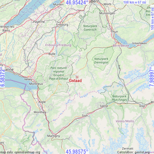
Gstaad GPS coordinates[2]
46° 28' 19.74" North, 7° 17' 12.66" East
| Map corner | latitude | longitude |
|---|---|---|
| Upper-left | 46.95424°, | 6.58372° |
| Center: | 46.47215°, | 7.28685° |
| Lower-right: | 45.98575°, | 7.98997° |
| Map W x H: | 107.7×107.7 km | = 66.9×66.9mi |
| max Lat: | 47.76737° ⇑86.6% North |
| Gstaad: | 46.47215° |
| min Lat: | ⇓13.4% South 45.83203° |
| min Long | Gstaad | max Long |
| 5.97153° | 7.28685° | 10.44624° |
| W 20.2%⇐ | ⇒79.8% E |
Elevation
Elevation of Gstaad is 1055 m = 3461 ft, and this is 496.8 m = 1630 ft above average elevation for this country.
| Max E: |
1845 m = 6053 ft | 4% |
| Gstaad | 1055 m 3461 ft | |
| Avg. | 558.2 m = 1831 ft | |
Min E: |
197 m = 646 ft | 96% |
See also: Switzerland elevation on elevation.city.
Geographical zone
Gstaad is located in North temperate zone (between Tropic of Cancer and the Arctic Circle). Distance of this North polar circle is 2234 km =1388.1 mi to North.| Distance of | km | miles | from Gstaad |
|---|---|---|---|
| North Pole | 4839.8 | 3007.3 | to North |
| Arctic Circle | 2234 | 1388.1 | to North |
| Tropic Cancer | 2561.3 | 1591.5 | to South |
| Equator | 5167.2 | 3210.7 | to South |


Nearby cities:
15 places around Gstaad: (largest is in red/bold)
• Albeuve
18.3 km =11.4 mi,  285°
285°
• Boltigen
19.1 km =11.9 mi,  24°
24°
• Broc
20.6 km =12.8 mi,  315°
315°
• Charmey
18.9 km =11.7 mi,  330°
330°
• Château-d'Oex
11.9 km =7.4 mi,  271°
271°
• Enney
18.7 km =11.6 mi,  304°
304°
• Grandvillard
17.1 km =10.6 mi, 295°
• Gruyères
20 km =12.4 mi,  308°
308°
• Jaun
15.5 km =9.6 mi,  356°
356°
• Lenk
12.1 km =7.5 mi,  97°
97°
• Rossinière
15.6 km =9.7 mi, 268°
• Rougemont
6.4 km =4 mi, 286°
• Saanen
2.8 km =1.7 mi, 313°
• Sankt Stephan
9.2 km =5.7 mi,  64°
64°
• Zweisimmen
11.4 km =7.1 mi,  35°
35°
Sources, notices
• [Note1] Compared only with cities in Switzerland existing in our database
• [Src1] Map data: © OpenStreetMap contributors (CC-BY-SA)
• [Src2] Other city data from geonames.org with taken over terms of usage.
• [Src3] Geographical zone / Annual Mean Temperature by Robert A. Rohde @ Wikipedia
