Saanen geodata
Saanen (Bern) is a populated place; located in Switzerland in Europe/Zurich (GMT+2) time zone. With population of 6,621 people, there are 248 cities with bigger population in this country. Compared to other cities in Switzerland, 86% of cities are located further ↑North; 80.6% of cities are located further →East and 95.2% of cities have lower elevation than Saanen. Note1


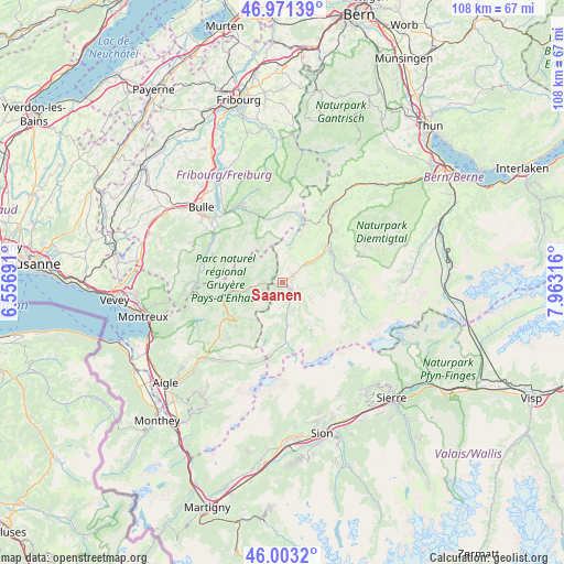
Saanen GPS coordinates[2]
46° 29' 22.02" North, 7° 15' 36.108" East
| Map corner | latitude | longitude |
|---|---|---|
| Upper-left | 46.97139°, | 6.55691° |
| Center: | 46.48945°, | 7.26003° |
| Lower-right: | 46.0032°, | 7.96316° |
| Map W x H: | 107.7×107.7 km | = 66.9×66.9mi |
| max Lat: | 47.76737° ⇑86% North |
| Saanen: | 46.48945° |
| min Lat: | ⇓14% South 45.83203° |
| min Long | Saanen | max Long |
| 5.97153° | 7.26003° | 10.44624° |
| W 19.4%⇐ | ⇒80.6% E |
Elevation
Elevation of Saanen is 1010 m = 3314 ft, and this is 451.8 m = 1482 ft above average elevation for this country.
| Max E: |
1845 m = 6053 ft | 4.8% |
| Saanen | 1010 m 3314 ft | |
| Avg. | 558.2 m = 1831 ft | |
Min E: |
197 m = 646 ft | 95.2% |
See also: Switzerland elevation on elevation.city.
Geographical zone
Saanen is located in North temperate zone (between Tropic of Cancer and the Arctic Circle). Distance of this North polar circle is 2232 km =1386.9 mi to North.| Distance of | km | miles | from Saanen |
|---|---|---|---|
| North Pole | 4837.9 | 3006.1 | to North |
| Arctic Circle | 2232 | 1386.9 | to North |
| Tropic Cancer | 2563.2 | 1592.7 | to South |
| Equator | 5169.1 | 3211.9 | to South |


Nearby cities:
15 places around Saanen: (largest is in red/bold)
• Albeuve
15.9 km =9.9 mi,  281°
281°
• Boltigen
18.4 km =11.4 mi,  32°
32°
• Broc
17.8 km =11.1 mi,  316°
316°
• Charmey
16.2 km =10.1 mi,  333°
333°
• Château-d'Oex
10 km =6.2 mi,  260°
260°
• Enney
16 km =9.9 mi,  302°
302°
• Grandvillard
14.4 km =8.9 mi,  292°
292°
• Gruyères
17.2 km =10.7 mi,  307°
307°
• Gstaad
2.8 km =1.7 mi,  133°
133°
• Jaun
13.6 km =8.5 mi,  5°
5°
• Lenk
14.4 km =8.9 mi,  103°
103°
• Rossinière
13.7 km =8.5 mi, 259°
• Rougemont
4.1 km =2.5 mi,  267°
267°
• Sankt Stephan
10.6 km =6.6 mi,  78°
78°
• Zweisimmen
11.3 km =7 mi,  49°
49°
Sources, notices
• [Note1] Compared only with cities in Switzerland existing in our database
• [Src1] Map data: © OpenStreetMap contributors (CC-BY-SA)
• [Src2] Other city data from geonames.org with taken over terms of usage.
• [Src3] Geographical zone / Annual Mean Temperature by Robert A. Rohde @ Wikipedia
