Bottens geodata
Bottens (Vaud) is a populated place; located in Switzerland in Europe/Zurich (GMT+2) time zone. With population of 1,030 people, there are 1309 cities with bigger population in this country. Compared to other cities in Switzerland, 81.7% of cities are located further ↑North; 93.2% of cities are located further →East and 84.5% of cities have lower elevation than Bottens. Note1


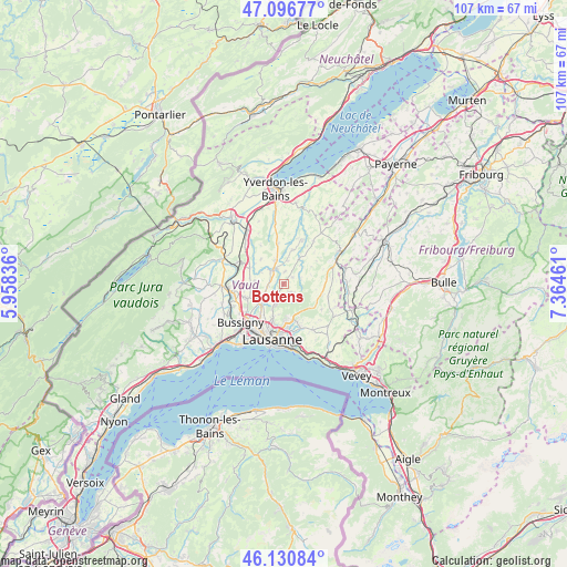
Bottens GPS coordinates[2]
46° 36' 57.456" North, 6° 39' 41.364" East
| Map corner | latitude | longitude |
|---|---|---|
| Upper-left | 47.09677°, | 5.95836° |
| Center: | 46.61596°, | 6.66149° |
| Lower-right: | 46.13084°, | 7.36461° |
| Map W x H: | 107.4×107.4 km | = 66.7×66.7mi |
| max Lat: | 47.76737° ⇑81.7% North |
| Bottens: | 46.61596° |
| min Lat: | ⇓18.3% South 45.83203° |
| min Long | Bottens | max Long |
| 5.97153° | 6.66149° | 10.44624° |
| W 6.8%⇐ | ⇒93.2% E |
Elevation
Elevation of Bottens is 730 m = 2395 ft, and this is 171.8 m = 564 ft above average elevation for this country.
| Max E: |
1845 m = 6053 ft | 15.5% |
| Bottens | 730 m 2395 ft | |
| Avg. | 558.2 m = 1831 ft | |
Min E: |
197 m = 646 ft | 84.5% |
See also: Switzerland elevation on elevation.city.
Geographical zone
Bottens is located in North temperate zone (between Tropic of Cancer and the Arctic Circle). Distance of this North polar circle is 2218 km =1378.2 mi to North.| Distance of | km | miles | from Bottens |
|---|---|---|---|
| North Pole | 4823.9 | 2997.4 | to North |
| Arctic Circle | 2218 | 1378.2 | to North |
| Tropic Cancer | 2577.3 | 1601.5 | to South |
| Equator | 5183.2 | 3220.7 | to South |


Nearby cities:
15 places around Bottens: (largest is in red/bold)
• Assens
3 km =1.9 mi,  263°
263°
• Blécherette
9 km =5.6 mi,  199°
199°
• Cheseaux
5.4 km =3.4 mi,  232°
232°
• Corcelles-le-Jorat
6.3 km =3.9 mi,  99°
99°
• Daillens
8.6 km =5.3 mi,  273°
273°
• Echallens
3.6 km =2.2 mi,  322°
322°
• Epalinges
7.5 km =4.7 mi,  175°
175°
• Froideville
2.2 km =1.4 mi,  137°
137°
• Goumoens-la-Ville
6.5 km =4 mi, 317°
• Le Mont-sur-Lausanne
6.8 km =4.2 mi, 199°
• Penthéréaz
8.5 km =5.3 mi,  328°
328°
• Romanel-sur-Lausanne
7.2 km =4.5 mi,  216°
216°
• Rueyres
8.9 km =5.5 mi,  15°
15°
• Sottens
7.5 km =4.7 mi,  54°
54°
• Vuarrens
7.8 km =4.8 mi,  352°
352°
Sources, notices
• [Note1] Compared only with cities in Switzerland existing in our database
• [Src1] Map data: © OpenStreetMap contributors (CC-BY-SA)
• [Src2] Other city data from geonames.org with taken over terms of usage.
• [Src3] Geographical zone / Annual Mean Temperature by Robert A. Rohde @ Wikipedia
